You are here: Home > Network List > TA - USArray Transportable Network (new EarthScope stations) Stations List
> Station 138A Matatall Enterprise, Big Sandy, TX, USA > Earthquake Result Viewer
138A Matatall Enterprise, Big Sandy, TX, USA - Earthquake Result Viewer
| Earthquake location: |
Near East Coast Of Honshu, Japan |
| Earthquake latitude/longitude: |
39.7/142.4 |
| Earthquake time(UTC): |
2010/07/04 (185) 21:55:51 GMT |
| Earthquake Depth: |
27 km |
| Earthquake Magnitude: |
6.4 MB, 6.1 MS, 6.3 MW, 6.2 MW |
| Earthquake Catalog/Contributor: |
WHDF/NEIC |
|
| Network: |
TA USArray Transportable Network (new EarthScope stations) |
| Station: |
138A Matatall Enterprise, Big Sandy, TX, USA |
| Lat/Lon: |
32.66 N/95.09 W |
| Elevation: |
143 m |
|
| Distance: |
90.5 deg |
| Az: |
45.325 deg |
| Baz: |
319.426 deg |
| Ray Param: |
0.041667428 |
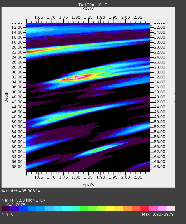
| Estimated Moho Depth: |
32.0 km |
| Estimated Crust Vp/Vs: |
1.80 |
| Assumed Crust Vp: |
6.245 km/s |
| Estimated Crust Vs: |
3.474 km/s |
| Estimated Crust Poisson's Ratio: |
0.28 |
|
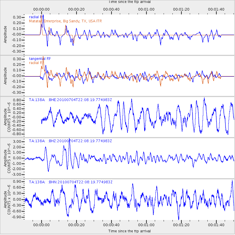
| Radial Match: |
85.08534 % |
| Radial Bump: |
353 |
| Transverse Match: |
78.008995 % |
| Transverse Bump: |
400 |
| SOD ConfigId: |
319893 |
| Insert Time: |
2011-01-05 00:36:58.820 +0000 |
| GWidth: |
2.5 |
| Max Bumps: |
400 |
| Tol: |
0.001 |
|
Signal To Noise
| Channel | StoN | STA | LTA |
| TA:138A: :BHZ:20100704T22:08:19.774983Z | 8.826036 | 1.1226742E-6 | 1.2720027E-7 |
| TA:138A: :BHN:20100704T22:08:19.774983Z | 0.6898394 | 1.1355911E-7 | 1.6461674E-7 |
| TA:138A: :BHE:20100704T22:08:19.774983Z | 1.7930052 | 3.1237826E-7 | 1.7422049E-7 |
| Arrivals |
| Ps | 4.2 SECOND |
| PpPs | 14 SECOND |
| PsPs/PpSs | 18 SECOND |


