You are here: Home > Network List > TA - USArray Transportable Network (new EarthScope stations) Stations List
> Station V35A Meyer Ranch, Chandler, OK, USA > Earthquake Result Viewer
V35A Meyer Ranch, Chandler, OK, USA - Earthquake Result Viewer

| Earthquake location: |
Near East Coast Of Honshu, Japan |
| Earthquake latitude/longitude: |
39.7/142.4 |
| Earthquake time(UTC): |
2010/07/04 (185) 21:55:51 GMT |
| Earthquake Depth: |
27 km |
| Earthquake Magnitude: |
6.4 MB, 6.1 MS, 6.3 MW, 6.2 MW |
| Earthquake Catalog/Contributor: |
WHDF/NEIC |
|
| Network: |
TA USArray Transportable Network (new EarthScope stations) |
| Station: |
V35A Meyer Ranch, Chandler, OK, USA |
| Lat/Lon: |
35.76 N/96.84 W |
| Elevation: |
280 m |
|
| Distance: |
87.2 deg |
| Az: |
44.385 deg |
| Baz: |
318.428 deg |
| Ray Param: |
0.043466795 |
| Estimated Moho Depth: |
19.0 km |
| Estimated Crust Vp/Vs: |
2.10 |
| Assumed Crust Vp: |
6.426 km/s |
| Estimated Crust Vs: |
3.064 km/s |
| Estimated Crust Poisson's Ratio: |
0.35 |
|
| Radial Match: |
88.340004 % |
| Radial Bump: |
361 |
| Transverse Match: |
85.54254 % |
| Transverse Bump: |
383 |
| SOD ConfigId: |
319893 |
| Insert Time: |
2011-01-05 00:37:10.158 +0000 |
| GWidth: |
2.5 |
| Max Bumps: |
400 |
| Tol: |
0.001 |
|
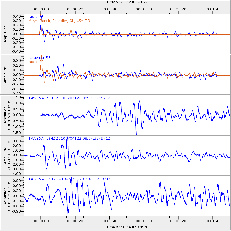
Signal To Noise
| Channel | StoN | STA | LTA |
| TA:V35A: :BHZ:20100704T22:08:04.324971Z | 15.306301 | 1.4345766E-6 | 9.372458E-8 |
| TA:V35A: :BHN:20100704T22:08:04.324971Z | 3.1258197 | 3.4964114E-7 | 1.11855826E-7 |
| TA:V35A: :BHE:20100704T22:08:04.324971Z | 4.409397 | 4.783284E-7 | 1.0847933E-7 |
| Arrivals |
| Ps | 3.3 SECOND |
| PpPs | 9.0 SECOND |
| PsPs/PpSs | 12 SECOND |


