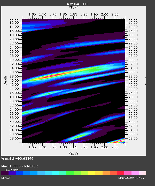
W36A Wetumka, OK, USA - Earthquake Result Viewer
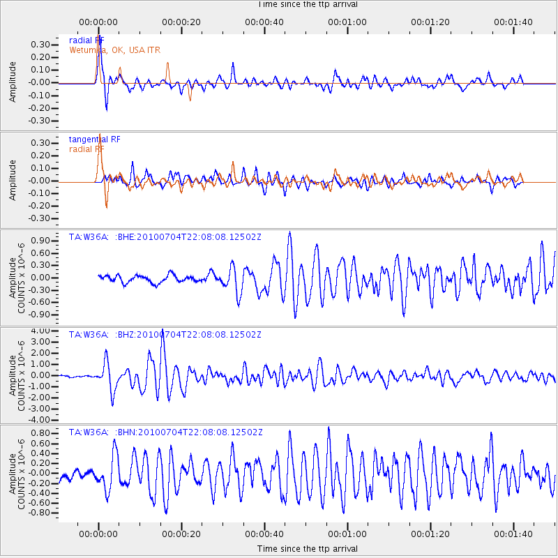
Earthquake location: Near East Coast Of Honshu, Japan
Earthquake latitude/longitude: 39.7/142.4
Earthquake time(UTC): 2010/07/04 (185) 21:55:51 GMT
Earthquake Depth: 27 km
Earthquake Magnitude: 6.4 MB, 6.1 MS, 6.3 MW, 6.2 MW
Earthquake Catalog/Contributor: WHDF/NEIC
Network: TA USArray Transportable Network (new EarthScope stations)
Station: W36A Wetumka, OK, USA
Lat/Lon: 35.14 N/96.23 W
Elevation: 251 m
Distance: 88.0 deg
Az: 44.422 deg
Baz: 318.783 deg
Ray Param: 0.04288685
Estimated Moho Depth: 68.5 km
Estimated Crust Vp/Vs: 2.10
Assumed Crust Vp: 6.426 km/s
Estimated Crust Vs: 3.067 km/s
Estimated Crust Poisson's Ratio: 0.35
Radial Match: 90.63399 %
Radial Bump: 400
Transverse Match: 83.9734 %
Transverse Bump: 400
SOD ConfigId: 319893
Insert Time: 2011-01-05 00:37:41.478 +0000
GWidth: 2.5
Max Bumps: 400
Tol: 0.001

Signal To Noise

ChannelStoNSTALTA
TA:W36A: :BHZ:20100704T22:08:08.12502Z10.9581221.254713E-61.1450072E-7
TA:W36A: :BHN:20100704T22:08:08.12502Z3.5929213.5039793E-79.752453E-8
TA:W36A: :BHE:20100704T22:08:08.12502Z3.6825823.1566745E-78.571905E-8
Arrivals
Ps12 SECOND
PpPs32 SECOND
PsPs/PpSs44 SECOND