You are here: Home > Network List > TA - USArray Transportable Network (new EarthScope stations) Stations List
> Station Z38A Mt. Pleasant, TX, USA > Earthquake Result Viewer
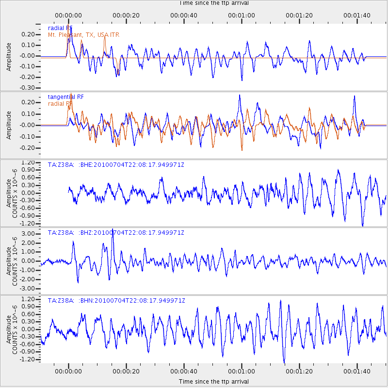
Z38A Mt. Pleasant, TX, USA - Earthquake Result Viewer
*The percent match for this event was below the threshold and hence no stack was calculated.
| Earthquake location: |
Near East Coast Of Honshu, Japan |
| Earthquake latitude/longitude: |
39.7/142.4 |
| Earthquake time(UTC): |
2010/07/04 (185) 21:55:51 GMT |
| Earthquake Depth: |
27 km |
| Earthquake Magnitude: |
6.4 MB, 6.1 MS, 6.3 MW, 6.2 MW |
| Earthquake Catalog/Contributor: |
WHDF/NEIC |
|
| Network: |
TA USArray Transportable Network (new EarthScope stations) |
| Station: |
Z38A Mt. Pleasant, TX, USA |
| Lat/Lon: |
33.25 N/94.99 W |
| Elevation: |
116 m |
|
| Distance: |
90.1 deg |
| Az: |
44.877 deg |
| Baz: |
319.485 deg |
| Ray Param: |
$rayparam |
*The percent match for this event was below the threshold and hence was not used in the summary stack. |
|
| Radial Match: |
75.64613 % |
| Radial Bump: |
400 |
| Transverse Match: |
71.605415 % |
| Transverse Bump: |
399 |
| SOD ConfigId: |
319893 |
| Insert Time: |
2011-01-05 00:38:12.966 +0000 |
| GWidth: |
2.5 |
| Max Bumps: |
400 |
| Tol: |
0.001 |
|
Signal To Noise
| Channel | StoN | STA | LTA |
| TA:Z38A: :BHZ:20100704T22:08:17.949971Z | 7.0743766 | 9.764921E-7 | 1.3803223E-7 |
| TA:Z38A: :BHN:20100704T22:08:17.949971Z | 1.083981 | 2.5054942E-7 | 2.311382E-7 |
| TA:Z38A: :BHE:20100704T22:08:17.949971Z | 1.4761913 | 2.8638982E-7 | 1.940059E-7 |
| Arrivals |
| Ps | |
| PpPs | |
| PsPs/PpSs | |


