You are here: Home > Network List > TA - USArray Transportable Network (new EarthScope stations) Stations List
> Station Y35A Marietta, OK, USA > Earthquake Result Viewer
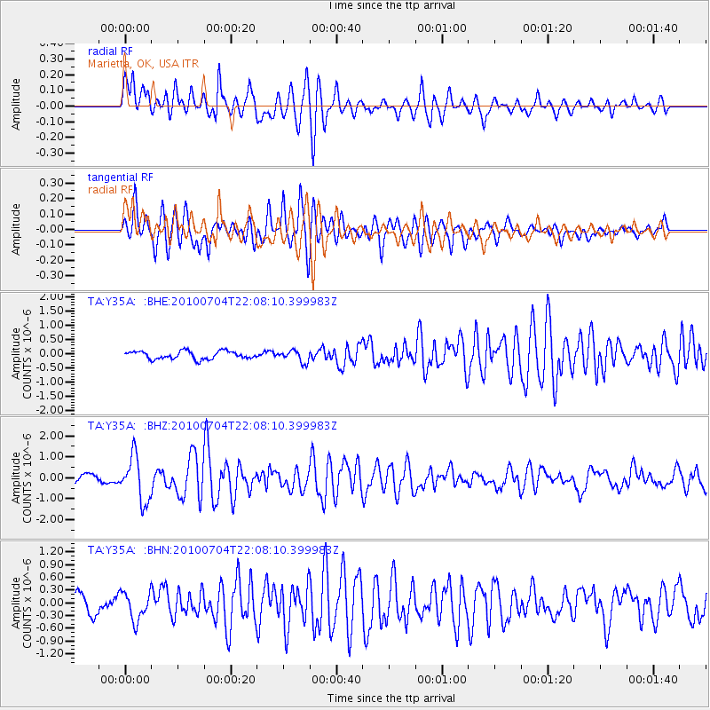
Y35A Marietta, OK, USA - Earthquake Result Viewer
*The percent match for this event was below the threshold and hence no stack was calculated.
| Earthquake location: |
Near East Coast Of Honshu, Japan |
| Earthquake latitude/longitude: |
39.7/142.4 |
| Earthquake time(UTC): |
2010/07/04 (185) 21:55:51 GMT |
| Earthquake Depth: |
27 km |
| Earthquake Magnitude: |
6.4 MB, 6.1 MS, 6.3 MW, 6.2 MW |
| Earthquake Catalog/Contributor: |
WHDF/NEIC |
|
| Network: |
TA USArray Transportable Network (new EarthScope stations) |
| Station: |
Y35A Marietta, OK, USA |
| Lat/Lon: |
33.91 N/97.04 W |
| Elevation: |
214 m |
|
| Distance: |
88.5 deg |
| Az: |
45.739 deg |
| Baz: |
318.366 deg |
| Ray Param: |
$rayparam |
*The percent match for this event was below the threshold and hence was not used in the summary stack. |
|
| Radial Match: |
78.654915 % |
| Radial Bump: |
400 |
| Transverse Match: |
74.43765 % |
| Transverse Bump: |
400 |
| SOD ConfigId: |
319893 |
| Insert Time: |
2011-01-05 00:38:17.957 +0000 |
| GWidth: |
2.5 |
| Max Bumps: |
400 |
| Tol: |
0.001 |
|
Signal To Noise
| Channel | StoN | STA | LTA |
| TA:Y35A: :BHZ:20100704T22:08:10.399983Z | 5.9024644 | 1.081993E-6 | 1.8331207E-7 |
| TA:Y35A: :BHN:20100704T22:08:10.399983Z | 1.4836439 | 3.2551202E-7 | 2.1940038E-7 |
| TA:Y35A: :BHE:20100704T22:08:10.399983Z | 1.4965277 | 2.0633841E-7 | 1.378781E-7 |
| Arrivals |
| Ps | |
| PpPs | |
| PsPs/PpSs | |


