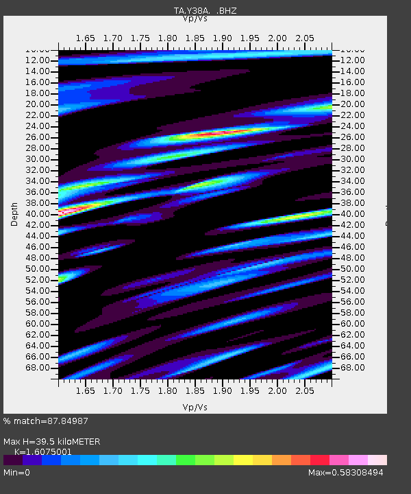
Y38A Idabel, OK, USA - Earthquake Result Viewer
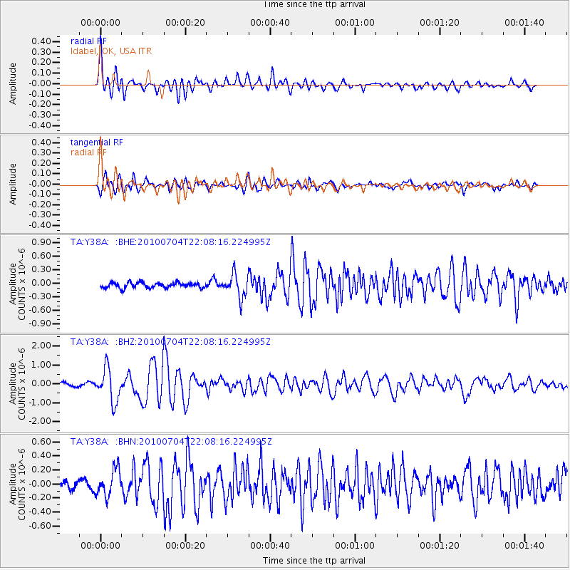
Earthquake location: Near East Coast Of Honshu, Japan
Earthquake latitude/longitude: 39.7/142.4
Earthquake time(UTC): 2010/07/04 (185) 21:55:51 GMT
Earthquake Depth: 27 km
Earthquake Magnitude: 6.4 MB, 6.1 MS, 6.3 MW, 6.2 MW
Earthquake Catalog/Contributor: WHDF/NEIC
Network: TA USArray Transportable Network (new EarthScope stations)
Station: Y38A Idabel, OK, USA
Lat/Lon: 33.93 N/94.73 W
Elevation: 118 m
Distance: 89.7 deg
Az: 44.277 deg
Baz: 319.624 deg
Ray Param: 0.041722134
Estimated Moho Depth: 39.5 km
Estimated Crust Vp/Vs: 1.61
Assumed Crust Vp: 6.245 km/s
Estimated Crust Vs: 3.885 km/s
Estimated Crust Poisson's Ratio: 0.18
Radial Match: 87.84987 %
Radial Bump: 400
Transverse Match: 85.57164 %
Transverse Bump: 400
SOD ConfigId: 319893
Insert Time: 2011-01-05 00:38:42.568 +0000
GWidth: 2.5
Max Bumps: 400
Tol: 0.001

Signal To Noise

ChannelStoNSTALTA
TA:Y38A: :BHZ:20100704T22:08:16.224995Z12.1736239.064149E-77.445729E-8
TA:Y38A: :BHN:20100704T22:08:16.224995Z2.7661071.9704503E-77.1235505E-8
TA:Y38A: :BHE:20100704T22:08:16.224995Z4.53066442.6024438E-75.744067E-8
Arrivals
Ps3.9 SECOND
PpPs16 SECOND
PsPs/PpSs20 SECOND