You are here: Home > Network List > US - United States National Seismic Network Stations List
> Station HAWA Hanford, Washington, USA > Earthquake Result Viewer
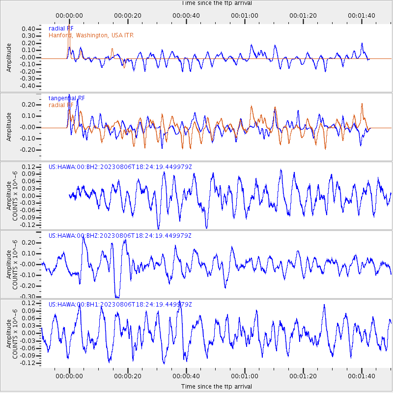
HAWA Hanford, Washington, USA - Earthquake Result Viewer
*The percent match for this event was below the threshold and hence no stack was calculated.
| Earthquake location: |
Kyushu, Japan |
| Earthquake latitude/longitude: |
30.8/131.4 |
| Earthquake time(UTC): |
2023/08/06 (218) 18:12:41 GMT |
| Earthquake Depth: |
13 km |
| Earthquake Magnitude: |
5.5 Mww |
| Earthquake Catalog/Contributor: |
NEIC PDE/us |
|
| Network: |
US United States National Seismic Network |
| Station: |
HAWA Hanford, Washington, USA |
| Lat/Lon: |
46.39 N/119.53 W |
| Elevation: |
364 m |
|
| Distance: |
80.1 deg |
| Az: |
41.613 deg |
| Baz: |
304.319 deg |
| Ray Param: |
$rayparam |
*The percent match for this event was below the threshold and hence was not used in the summary stack. |
|
| Radial Match: |
60.0833 % |
| Radial Bump: |
400 |
| Transverse Match: |
66.68989 % |
| Transverse Bump: |
400 |
| SOD ConfigId: |
31937991 |
| Insert Time: |
2023-08-20 18:34:13.952 +0000 |
| GWidth: |
2.5 |
| Max Bumps: |
400 |
| Tol: |
0.001 |
|
Signal To Noise
| Channel | StoN | STA | LTA |
| US:HAWA:00:BHZ:20230806T18:24:19.449979Z | 1.8640666 | 1.0917302E-7 | 5.8567128E-8 |
| US:HAWA:00:BH1:20230806T18:24:19.449979Z | 1.378285 | 6.302416E-8 | 4.5726505E-8 |
| US:HAWA:00:BH2:20230806T18:24:19.449979Z | 2.1096122 | 7.079415E-8 | 3.35579E-8 |
| Arrivals |
| Ps | |
| PpPs | |
| PsPs/PpSs | |


