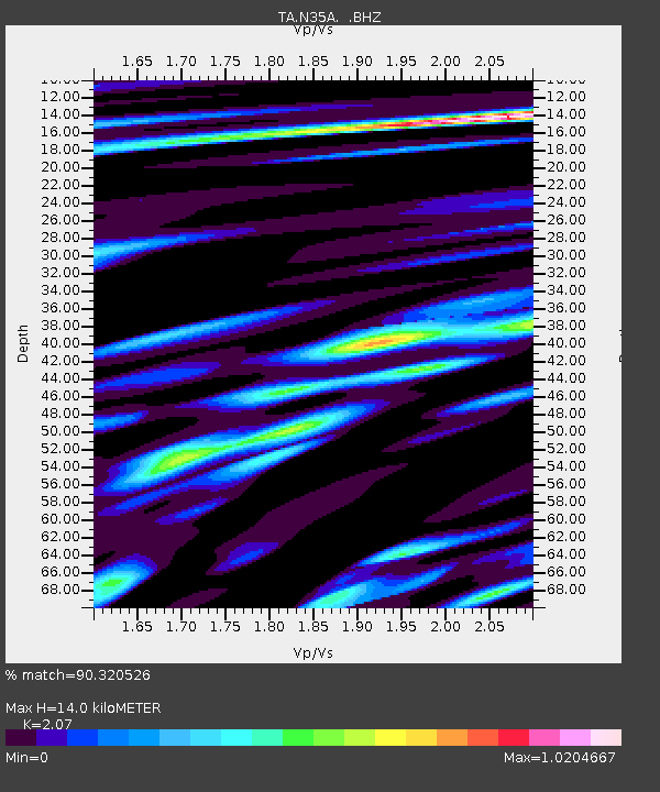
N35A Tabor, IA, USA - Earthquake Result Viewer
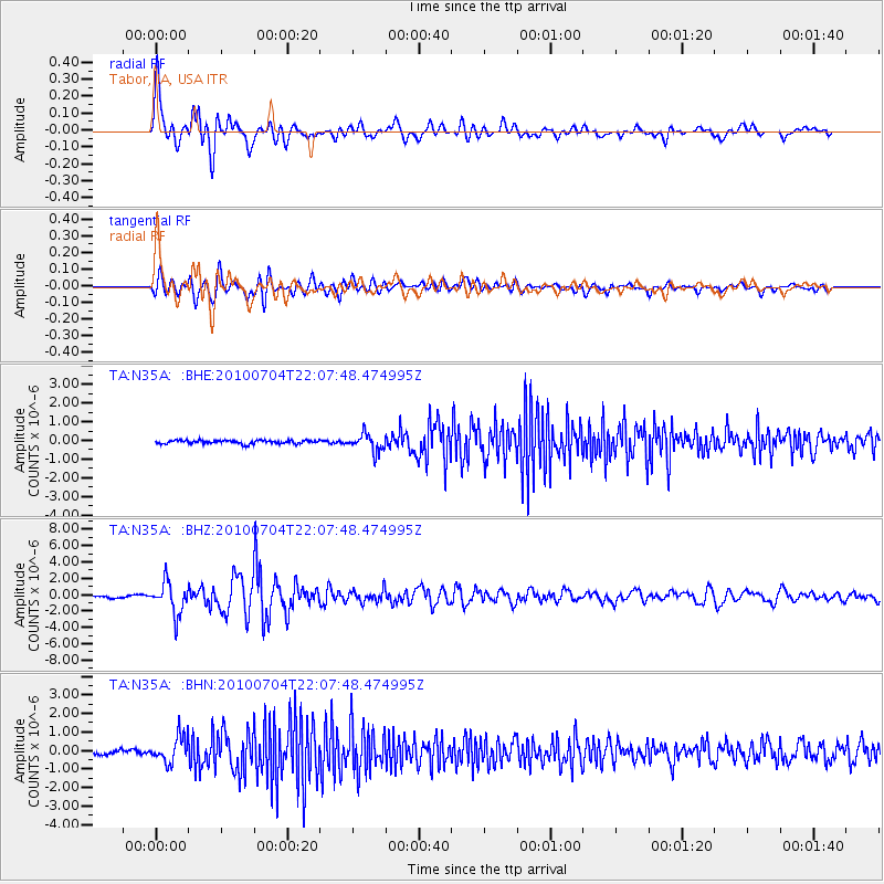
Earthquake location: Near East Coast Of Honshu, Japan
Earthquake latitude/longitude: 39.7/142.4
Earthquake time(UTC): 2010/07/04 (185) 21:55:51 GMT
Earthquake Depth: 27 km
Earthquake Magnitude: 6.4 MB, 6.1 MS, 6.3 MW, 6.2 MW
Earthquake Catalog/Contributor: WHDF/NEIC
Network: TA USArray Transportable Network (new EarthScope stations)
Station: N35A Tabor, IA, USA
Lat/Lon: 40.86 N/95.64 W
Elevation: 353 m
Distance: 84.0 deg
Az: 40.304 deg
Baz: 318.853 deg
Ray Param: 0.04576036
Estimated Moho Depth: 14.0 km
Estimated Crust Vp/Vs: 2.07
Assumed Crust Vp: 6.498 km/s
Estimated Crust Vs: 3.139 km/s
Estimated Crust Poisson's Ratio: 0.35
Radial Match: 90.320526 %
Radial Bump: 400
Transverse Match: 85.42704 %
Transverse Bump: 400
SOD ConfigId: 319893
Insert Time: 2011-01-05 00:39:38.996 +0000
GWidth: 2.5
Max Bumps: 400
Tol: 0.001

Signal To Noise

ChannelStoNSTALTA
TA:N35A: :BHZ:20100704T22:07:48.474995Z12.2899011.9236195E-61.5652034E-7
TA:N35A: :BHN:20100704T22:07:48.474995Z4.8191646.960539E-71.444346E-7
TA:N35A: :BHE:20100704T22:07:48.474995Z5.07870154.677966E-79.2109495E-8
Arrivals
Ps2.4 SECOND
PpPs6.5 SECOND
PsPs/PpSs8.8 SECOND