You are here: Home > Network List > GT - Global Telemetered Seismograph Network (USAF/USGS) Stations List
> Station LPAZ La Paz , Bolivia > Earthquake Result Viewer
LPAZ La Paz , Bolivia - Earthquake Result Viewer
| Earthquake location: |
South Sandwich Islands Region |
| Earthquake latitude/longitude: |
-55.8/-27.1 |
| Earthquake time(UTC): |
2023/08/07 (219) 23:49:01 GMT |
| Earthquake Depth: |
16 km |
| Earthquake Magnitude: |
5.7 Mww |
| Earthquake Catalog/Contributor: |
NEIC PDE/us |
|
| Network: |
GT Global Telemetered Seismograph Network (USAF/USGS) |
| Station: |
LPAZ La Paz , Bolivia |
| Lat/Lon: |
16.17 S/68.08 W |
| Elevation: |
4817 m |
|
| Distance: |
50.4 deg |
| Az: |
304.993 deg |
| Baz: |
151.193 deg |
| Ray Param: |
0.06809943 |
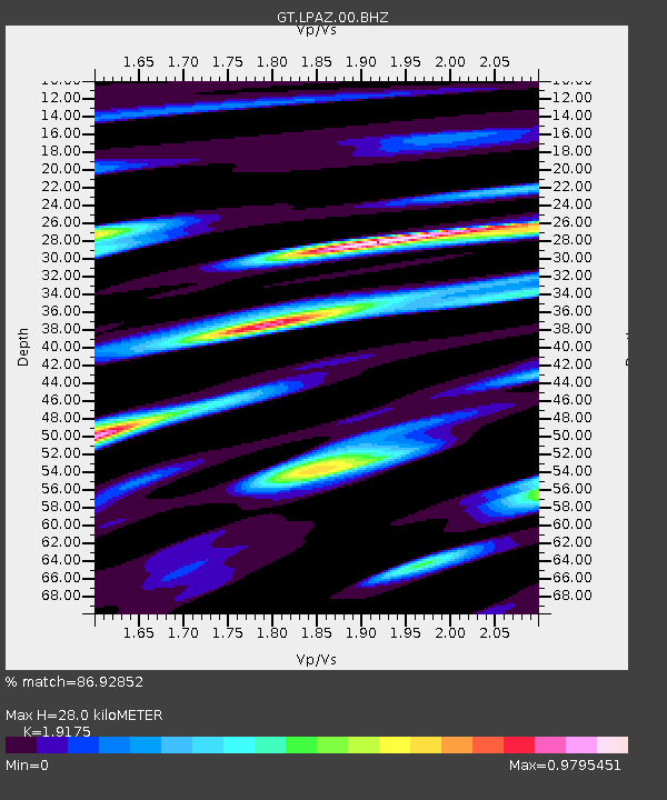
| Estimated Moho Depth: |
28.0 km |
| Estimated Crust Vp/Vs: |
1.92 |
| Assumed Crust Vp: |
6.454 km/s |
| Estimated Crust Vs: |
3.366 km/s |
| Estimated Crust Poisson's Ratio: |
0.31 |
|
| Radial Match: |
86.92852 % |
| Radial Bump: |
400 |
| Transverse Match: |
78.36729 % |
| Transverse Bump: |
400 |
| SOD ConfigId: |
31937991 |
| Insert Time: |
2023-08-21 23:53:30.132 +0000 |
| GWidth: |
2.5 |
| Max Bumps: |
400 |
| Tol: |
0.001 |
|

Signal To Noise
| Channel | StoN | STA | LTA |
| GT:LPAZ:00:BHZ:20230807T23:57:26.250013Z | 4.1864576 | 8.2705424E-7 | 1.9755467E-7 |
| GT:LPAZ:00:BHN:20230807T23:57:26.250013Z | 1.537637 | 2.4486184E-7 | 1.5924556E-7 |
| GT:LPAZ:00:BHE:20230807T23:57:26.250013Z | 4.0849004 | 2.8109062E-7 | 6.881211E-8 |
| Arrivals |
| Ps | 4.2 SECOND |
| PpPs | 12 SECOND |
| PsPs/PpSs | 16 SECOND |


