You are here: Home > Network List > TA - USArray Transportable Network (new EarthScope stations) Stations List
> Station M34A Aspy Farms, Fremont, NE, USA > Earthquake Result Viewer
M34A Aspy Farms, Fremont, NE, USA - Earthquake Result Viewer

| Earthquake location: |
Near East Coast Of Honshu, Japan |
| Earthquake latitude/longitude: |
39.7/142.4 |
| Earthquake time(UTC): |
2010/07/04 (185) 21:55:51 GMT |
| Earthquake Depth: |
27 km |
| Earthquake Magnitude: |
6.4 MB, 6.1 MS, 6.3 MW, 6.2 MW |
| Earthquake Catalog/Contributor: |
WHDF/NEIC |
|
| Network: |
TA USArray Transportable Network (new EarthScope stations) |
| Station: |
M34A Aspy Farms, Fremont, NE, USA |
| Lat/Lon: |
41.50 N/96.58 W |
| Elevation: |
415 m |
|
| Distance: |
83.0 deg |
| Az: |
40.413 deg |
| Baz: |
318.248 deg |
| Ray Param: |
0.04643385 |
| Estimated Moho Depth: |
21.5 km |
| Estimated Crust Vp/Vs: |
1.85 |
| Assumed Crust Vp: |
6.498 km/s |
| Estimated Crust Vs: |
3.517 km/s |
| Estimated Crust Poisson's Ratio: |
0.29 |
|
| Radial Match: |
95.55086 % |
| Radial Bump: |
400 |
| Transverse Match: |
81.65739 % |
| Transverse Bump: |
400 |
| SOD ConfigId: |
319893 |
| Insert Time: |
2011-01-05 00:40:39.387 +0000 |
| GWidth: |
2.5 |
| Max Bumps: |
400 |
| Tol: |
0.001 |
|
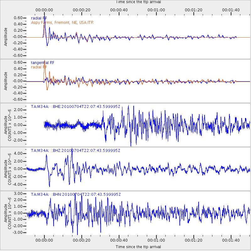
Signal To Noise
| Channel | StoN | STA | LTA |
| TA:M34A: :BHZ:20100704T22:07:43.599995Z | 6.924657 | 1.7874249E-6 | 2.5812471E-7 |
| TA:M34A: :BHN:20100704T22:07:43.599995Z | 3.0833538 | 8.599411E-7 | 2.7889797E-7 |
| TA:M34A: :BHE:20100704T22:07:43.599995Z | 2.5997415 | 7.461422E-7 | 2.8700632E-7 |
| Arrivals |
| Ps | 2.9 SECOND |
| PpPs | 9.2 SECOND |
| PsPs/PpSs | 12 SECOND |


