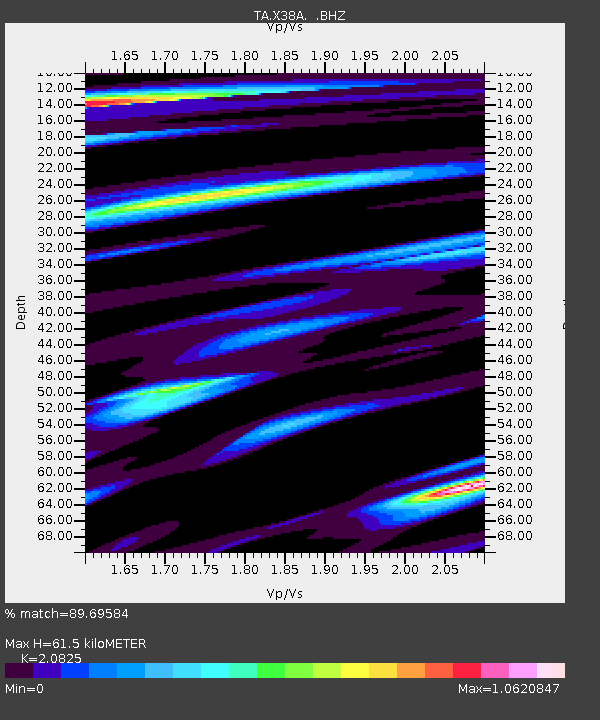
X38A Whitesboro, OK, USA - Earthquake Result Viewer

Earthquake location: Near East Coast Of Honshu, Japan
Earthquake latitude/longitude: 39.7/142.4
Earthquake time(UTC): 2010/07/04 (185) 21:55:51 GMT
Earthquake Depth: 27 km
Earthquake Magnitude: 6.4 MB, 6.1 MS, 6.3 MW, 6.2 MW
Earthquake Catalog/Contributor: WHDF/NEIC
Network: TA USArray Transportable Network (new EarthScope stations)
Station: X38A Whitesboro, OK, USA
Lat/Lon: 34.67 N/94.83 W
Elevation: 234 m
Distance: 89.1 deg
Az: 43.859 deg
Baz: 319.564 deg
Ray Param: 0.04206799
Estimated Moho Depth: 61.5 km
Estimated Crust Vp/Vs: 2.08
Assumed Crust Vp: 6.498 km/s
Estimated Crust Vs: 3.12 km/s
Estimated Crust Poisson's Ratio: 0.35
Radial Match: 89.69584 %
Radial Bump: 400
Transverse Match: 80.55763 %
Transverse Bump: 400
SOD ConfigId: 319893
Insert Time: 2011-01-05 00:41:03.973 +0000
GWidth: 2.5
Max Bumps: 400
Tol: 0.001

Signal To Noise

ChannelStoNSTALTA
TA:X38A: :BHZ:20100704T22:08:13.349995Z8.8350151.1731925E-61.3278895E-7
TA:X38A: :BHN:20100704T22:08:13.349995Z3.62653612.9406328E-78.108654E-8
TA:X38A: :BHE:20100704T22:08:13.349995Z4.51644044.4125426E-79.769957E-8
Arrivals
Ps10 SECOND
PpPs29 SECOND
PsPs/PpSs39 SECOND