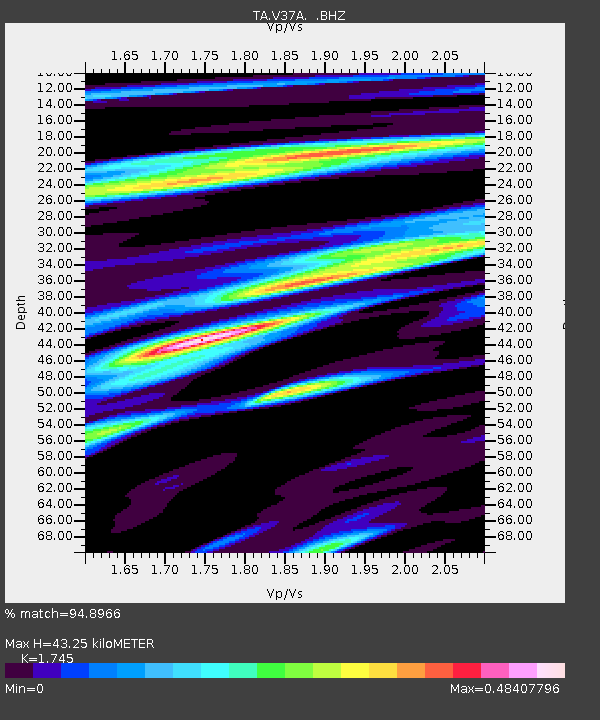
V37A Hulbert, OK, USA - Earthquake Result Viewer
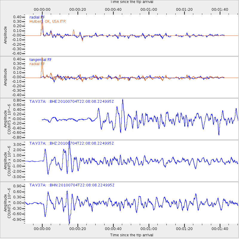
Earthquake location: Near East Coast Of Honshu, Japan
Earthquake latitude/longitude: 39.7/142.4
Earthquake time(UTC): 2010/07/04 (185) 21:55:51 GMT
Earthquake Depth: 27 km
Earthquake Magnitude: 6.4 MB, 6.1 MS, 6.3 MW, 6.2 MW
Earthquake Catalog/Contributor: WHDF/NEIC
Network: TA USArray Transportable Network (new EarthScope stations)
Station: V37A Hulbert, OK, USA
Lat/Lon: 35.88 N/95.14 W
Elevation: 219 m
Distance: 88.0 deg
Az: 43.266 deg
Baz: 319.37 deg
Ray Param: 0.042872448
Estimated Moho Depth: 43.25 km
Estimated Crust Vp/Vs: 1.75
Assumed Crust Vp: 6.498 km/s
Estimated Crust Vs: 3.724 km/s
Estimated Crust Poisson's Ratio: 0.26
Radial Match: 94.8966 %
Radial Bump: 312
Transverse Match: 85.73884 %
Transverse Bump: 400
SOD ConfigId: 319893
Insert Time: 2011-01-05 00:41:20.211 +0000
GWidth: 2.5
Max Bumps: 400
Tol: 0.001

Signal To Noise

ChannelStoNSTALTA
TA:V37A: :BHZ:20100704T22:08:08.224995Z26.5748581.2015165E-64.5212527E-8
TA:V37A: :BHN:20100704T22:08:08.224995Z7.49448633.510422E-74.684006E-8
TA:V37A: :BHE:20100704T22:08:08.224995Z5.8411042.3630187E-74.0455003E-8
Arrivals
Ps5.1 SECOND
PpPs18 SECOND
PsPs/PpSs23 SECOND