You are here: Home > Network List > US - United States National Seismic Network Stations List
> Station HAWA Hanford, Washington, USA > Earthquake Result Viewer
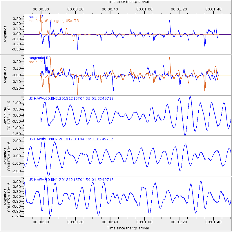
HAWA Hanford, Washington, USA - Earthquake Result Viewer
*The percent match for this event was below the threshold and hence no stack was calculated.
| Earthquake location: |
Sichuan, China |
| Earthquake latitude/longitude: |
28.3/105.0 |
| Earthquake time(UTC): |
2018/12/16 (350) 04:46:11 GMT |
| Earthquake Depth: |
27 km |
| Earthquake Magnitude: |
5.4 Mww |
| Earthquake Catalog/Contributor: |
NEIC PDE/us |
|
| Network: |
US United States National Seismic Network |
| Station: |
HAWA Hanford, Washington, USA |
| Lat/Lon: |
46.39 N/119.53 W |
| Elevation: |
364 m |
|
| Distance: |
95.5 deg |
| Az: |
29.179 deg |
| Baz: |
321.585 deg |
| Ray Param: |
$rayparam |
*The percent match for this event was below the threshold and hence was not used in the summary stack. |
|
| Radial Match: |
72.13997 % |
| Radial Bump: |
334 |
| Transverse Match: |
48.892834 % |
| Transverse Bump: |
400 |
| SOD ConfigId: |
3201911 |
| Insert Time: |
2018-12-30 04:57:09.955 +0000 |
| GWidth: |
2.5 |
| Max Bumps: |
400 |
| Tol: |
0.001 |
|
Signal To Noise
| Channel | StoN | STA | LTA |
| US:HAWA:00:BHZ:20181216T04:59:01.624971Z | 1.6941031 | 1.8055719E-6 | 1.0657981E-6 |
| US:HAWA:00:BH1:20181216T04:59:01.624971Z | 1.1900499 | 6.7837834E-7 | 5.700419E-7 |
| US:HAWA:00:BH2:20181216T04:59:01.624971Z | 0.6584922 | 3.795088E-7 | 5.7633E-7 |
| Arrivals |
| Ps | |
| PpPs | |
| PsPs/PpSs | |


