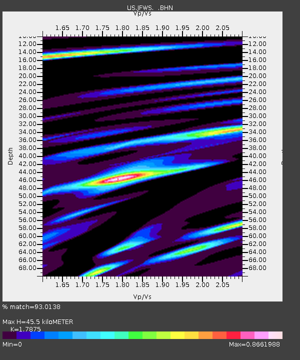
JFWS Jewell Farm, Wisconsin, USA - Earthquake Result Viewer
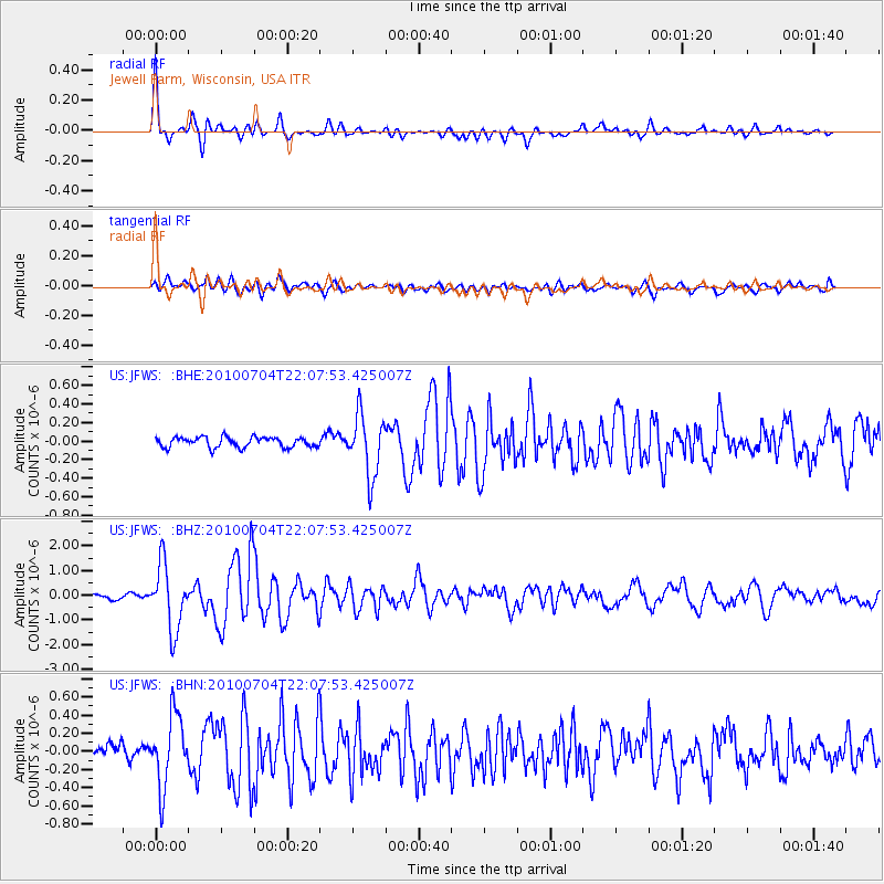
Earthquake location: Near East Coast Of Honshu, Japan
Earthquake latitude/longitude: 39.7/142.4
Earthquake time(UTC): 2010/07/04 (185) 21:55:51 GMT
Earthquake Depth: 27 km
Earthquake Magnitude: 6.4 MB, 6.1 MS, 6.3 MW, 6.2 MW
Earthquake Catalog/Contributor: WHDF/NEIC
Network: US United States National Seismic Network
Station: JFWS Jewell Farm, Wisconsin, USA
Lat/Lon: 42.91 N/90.25 W
Elevation: 335 m
Distance: 85.0 deg
Az: 35.873 deg
Baz: 322.018 deg
Ray Param: 0.045061234
Estimated Moho Depth: 45.5 km
Estimated Crust Vp/Vs: 1.79
Assumed Crust Vp: 6.53 km/s
Estimated Crust Vs: 3.653 km/s
Estimated Crust Poisson's Ratio: 0.27
Radial Match: 93.0138 %
Radial Bump: 400
Transverse Match: 82.19226 %
Transverse Bump: 400
SOD ConfigId: 319893
Insert Time: 2011-01-05 00:42:23.637 +0000
GWidth: 2.5
Max Bumps: 400
Tol: 0.001

Signal To Noise

ChannelStoNSTALTA
US:JFWS: :BHZ:20100704T22:07:53.425007Z16.3014341.3043555E-68.001477E-8
US:JFWS: :BHN:20100704T22:07:53.425007Z5.74759343.8841785E-76.7579215E-8
US:JFWS: :BHE:20100704T22:07:53.425007Z5.93889053.2676303E-75.502089E-8
Arrivals
Ps5.6 SECOND
PpPs19 SECOND
PsPs/PpSs25 SECOND