You are here: Home > Network List > MB - Montana Regional Seismic Network Stations List
> Station GBMT Granite Butte > Earthquake Result Viewer
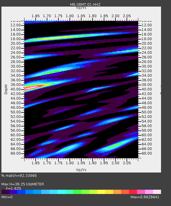
GBMT Granite Butte - Earthquake Result Viewer
| Earthquake location: |
Tonga Islands |
| Earthquake latitude/longitude: |
-15.0/-173.0 |
| Earthquake time(UTC): |
2023/08/08 (220) 18:38:56 GMT |
| Earthquake Depth: |
120 km |
| Earthquake Magnitude: |
6.2 Mi |
| Earthquake Catalog/Contributor: |
NEIC PDE/pt |
|
| Network: |
MB Montana Regional Seismic Network |
| Station: |
GBMT Granite Butte |
| Lat/Lon: |
46.86 N/112.46 W |
| Elevation: |
2248 m |
|
| Distance: |
82.0 deg |
| Az: |
37.112 deg |
| Baz: |
238.176 deg |
| Ray Param: |
0.046916544 |
| Estimated Moho Depth: |
39.25 km |
| Estimated Crust Vp/Vs: |
1.62 |
| Assumed Crust Vp: |
6.353 km/s |
| Estimated Crust Vs: |
3.91 km/s |
| Estimated Crust Poisson's Ratio: |
0.20 |
|
| Radial Match: |
92.33865 % |
| Radial Bump: |
331 |
| Transverse Match: |
86.62346 % |
| Transverse Bump: |
400 |
| SOD ConfigId: |
31937991 |
| Insert Time: |
2023-08-22 18:52:37.544 +0000 |
| GWidth: |
2.5 |
| Max Bumps: |
400 |
| Tol: |
0.001 |
|

Signal To Noise
| Channel | StoN | STA | LTA |
| MB:GBMT:01:HHZ:20230808T18:50:31.609985Z | 0.29865628 | 3.519735E-8 | 1.1785235E-7 |
| MB:GBMT:01:HHN:20230808T18:50:31.609985Z | 1.0059831 | 1.0665973E-7 | 1.0602537E-7 |
| MB:GBMT:01:HHE:20230808T18:50:31.609985Z | 1.0379041 | 2.4225326E-7 | 2.334062E-7 |
| Arrivals |
| Ps | 4.0 SECOND |
| PpPs | 16 SECOND |
| PsPs/PpSs | 20 SECOND |


