You are here: Home > Network List > O2 - Oklahoma Consolidated Temporary Seismic Networks Stations List
> Station SC19 Bison, Oklahoma, USA > Earthquake Result Viewer
SC19 Bison, Oklahoma, USA - Earthquake Result Viewer
| Earthquake location: |
Tonga Islands |
| Earthquake latitude/longitude: |
-15.0/-173.0 |
| Earthquake time(UTC): |
2023/08/08 (220) 18:38:56 GMT |
| Earthquake Depth: |
120 km |
| Earthquake Magnitude: |
6.2 Mi |
| Earthquake Catalog/Contributor: |
NEIC PDE/pt |
|
| Network: |
O2 Oklahoma Consolidated Temporary Seismic Networks |
| Station: |
SC19 Bison, Oklahoma, USA |
| Lat/Lon: |
36.22 N/97.84 W |
| Elevation: |
1116 m |
|
| Distance: |
87.2 deg |
| Az: |
51.498 deg |
| Baz: |
249.264 deg |
| Ray Param: |
0.043242812 |
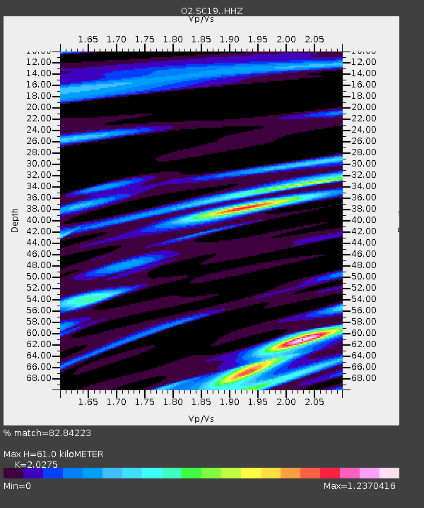
| Estimated Moho Depth: |
61.0 km |
| Estimated Crust Vp/Vs: |
2.03 |
| Assumed Crust Vp: |
6.483 km/s |
| Estimated Crust Vs: |
3.197 km/s |
| Estimated Crust Poisson's Ratio: |
0.34 |
|
| Radial Match: |
82.84223 % |
| Radial Bump: |
400 |
| Transverse Match: |
39.888153 % |
| Transverse Bump: |
400 |
| SOD ConfigId: |
31937991 |
| Insert Time: |
2023-08-22 18:56:13.939 +0000 |
| GWidth: |
2.5 |
| Max Bumps: |
400 |
| Tol: |
0.001 |
|

Signal To Noise
| Channel | StoN | STA | LTA |
| O2:SC19: :HHZ:20230808T18:50:57.575012Z | 1.2038039 | 1.07339886E-7 | 8.916725E-8 |
| O2:SC19: :HHN:20230808T18:50:57.575012Z | 0.4616645 | 1.73077E-7 | 3.7489778E-7 |
| O2:SC19: :HHE:20230808T18:50:57.575012Z | 0.68589014 | 1.2092123E-7 | 1.7629824E-7 |
| Arrivals |
| Ps | 9.9 SECOND |
| PpPs | 28 SECOND |
| PsPs/PpSs | 38 SECOND |


