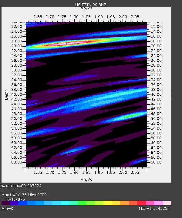
TZTN Tazewell, Tennessee, USA - Earthquake Result Viewer

Earthquake location: Near East Coast Of Honshu, Japan
Earthquake latitude/longitude: 39.7/142.4
Earthquake time(UTC): 2010/07/04 (185) 21:55:51 GMT
Earthquake Depth: 27 km
Earthquake Magnitude: 6.4 MB, 6.1 MS, 6.3 MW, 6.2 MW
Earthquake Catalog/Contributor: WHDF/NEIC
Network: US United States National Seismic Network
Station: TZTN Tazewell, Tennessee, USA
Lat/Lon: 36.54 N/83.55 W
Elevation: 394 m
Distance: 93.2 deg
Az: 35.406 deg
Baz: 326.284 deg
Ray Param: 0.04130829
Estimated Moho Depth: 18.75 km
Estimated Crust Vp/Vs: 1.77
Assumed Crust Vp: 6.476 km/s
Estimated Crust Vs: 3.664 km/s
Estimated Crust Poisson's Ratio: 0.26
Radial Match: 89.287224 %
Radial Bump: 400
Transverse Match: 64.75939 %
Transverse Bump: 400
SOD ConfigId: 319893
Insert Time: 2011-01-05 00:45:04.244 +0000
GWidth: 2.5
Max Bumps: 400
Tol: 0.001

Signal To Noise

ChannelStoNSTALTA
US:TZTN:00:BHZ:20100704T22:08:32.089985Z8.743466.61777E-77.5688234E-8
US:TZTN:00:BHN:20100704T22:08:32.089985Z4.47304872.0443035E-74.5702688E-8
US:TZTN:00:BHE:20100704T22:08:32.089985Z1.79097969.4728854E-85.28922E-8
Arrivals
Ps2.3 SECOND
PpPs7.8 SECOND
PsPs/PpSs10 SECOND