You are here: Home > Network List > TX - Texas Seismological Network Stations List
> Station BRDY Brady > Earthquake Result Viewer
BRDY Brady - Earthquake Result Viewer
| Earthquake location: |
Tonga Islands |
| Earthquake latitude/longitude: |
-15.0/-173.0 |
| Earthquake time(UTC): |
2023/08/08 (220) 18:38:56 GMT |
| Earthquake Depth: |
120 km |
| Earthquake Magnitude: |
6.2 Mi |
| Earthquake Catalog/Contributor: |
NEIC PDE/pt |
|
| Network: |
TX Texas Seismological Network |
| Station: |
BRDY Brady |
| Lat/Lon: |
31.27 N/99.00 W |
| Elevation: |
460 m |
|
| Distance: |
84.5 deg |
| Az: |
55.775 deg |
| Baz: |
248.929 deg |
| Ray Param: |
0.045152277 |
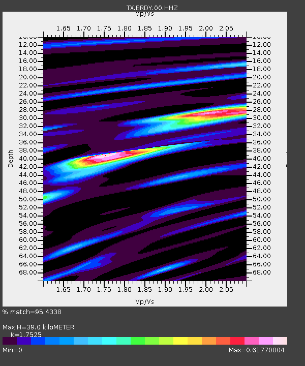
| Estimated Moho Depth: |
39.0 km |
| Estimated Crust Vp/Vs: |
1.75 |
| Assumed Crust Vp: |
6.498 km/s |
| Estimated Crust Vs: |
3.708 km/s |
| Estimated Crust Poisson's Ratio: |
0.26 |
|
| Radial Match: |
95.4338 % |
| Radial Bump: |
282 |
| Transverse Match: |
90.33016 % |
| Transverse Bump: |
400 |
| SOD ConfigId: |
31937991 |
| Insert Time: |
2023-08-22 19:00:07.216 +0000 |
| GWidth: |
2.5 |
| Max Bumps: |
400 |
| Tol: |
0.001 |
|

Signal To Noise
| Channel | StoN | STA | LTA |
| TX:BRDY:00:HHZ:20230808T18:50:44.544983Z | 0.70804715 | 5.5819065E-8 | 7.8835235E-8 |
| TX:BRDY:00:HH1:20230808T18:50:44.544983Z | 1.665792 | 8.2476625E-8 | 4.951196E-8 |
| TX:BRDY:00:HH2:20230808T18:50:44.544983Z | 0.9406477 | 5.7922932E-8 | 6.1577715E-8 |
| Arrivals |
| Ps | 4.6 SECOND |
| PpPs | 16 SECOND |
| PsPs/PpSs | 21 SECOND |


