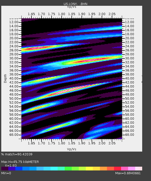
LONY Lake Ozonia, New York, USA - Earthquake Result Viewer
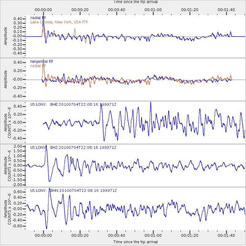
Earthquake location: Near East Coast Of Honshu, Japan
Earthquake latitude/longitude: 39.7/142.4
Earthquake time(UTC): 2010/07/04 (185) 21:55:51 GMT
Earthquake Depth: 27 km
Earthquake Magnitude: 6.4 MB, 6.1 MS, 6.3 MW, 6.2 MW
Earthquake Catalog/Contributor: WHDF/NEIC
Network: US United States National Seismic Network
Station: LONY Lake Ozonia, New York, USA
Lat/Lon: 44.62 N/74.58 W
Elevation: 440 m
Distance: 89.7 deg
Az: 25.424 deg
Baz: 332.367 deg
Ray Param: 0.04172224
Estimated Moho Depth: 45.75 km
Estimated Crust Vp/Vs: 1.83
Assumed Crust Vp: 6.419 km/s
Estimated Crust Vs: 3.508 km/s
Estimated Crust Poisson's Ratio: 0.29
Radial Match: 90.42039 %
Radial Bump: 400
Transverse Match: 77.34186 %
Transverse Bump: 400
SOD ConfigId: 319893
Insert Time: 2011-01-05 00:45:08.110 +0000
GWidth: 2.5
Max Bumps: 400
Tol: 0.001

Signal To Noise

ChannelStoNSTALTA
US:LONY: :BHZ:20100704T22:08:16.199971Z12.6466021.1126577E-68.7980766E-8
US:LONY: :BHN:20100704T22:08:16.199971Z5.83355054.074466E-76.9845385E-8
US:LONY: :BHE:20100704T22:08:16.199971Z4.85140042.482249E-75.1165618E-8
Arrivals
Ps6.0 SECOND
PpPs20 SECOND
PsPs/PpSs26 SECOND