You are here: Home > Network List > TX - Texas Seismological Network Stations List
> Station MB05 Klondike > Earthquake Result Viewer
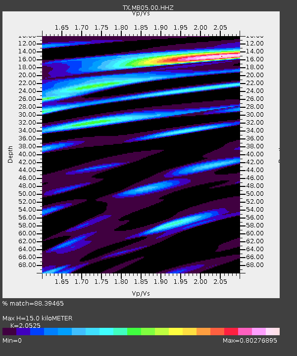
MB05 Klondike - Earthquake Result Viewer
| Earthquake location: |
Tonga Islands |
| Earthquake latitude/longitude: |
-15.0/-173.0 |
| Earthquake time(UTC): |
2023/08/08 (220) 18:38:56 GMT |
| Earthquake Depth: |
120 km |
| Earthquake Magnitude: |
6.2 Mi |
| Earthquake Catalog/Contributor: |
NEIC PDE/pt |
|
| Network: |
TX Texas Seismological Network |
| Station: |
MB05 Klondike |
| Lat/Lon: |
32.63 N/101.86 W |
| Elevation: |
882 m |
|
| Distance: |
82.8 deg |
| Az: |
53.601 deg |
| Baz: |
247.185 deg |
| Ray Param: |
0.046378814 |
| Estimated Moho Depth: |
15.0 km |
| Estimated Crust Vp/Vs: |
2.05 |
| Assumed Crust Vp: |
6.426 km/s |
| Estimated Crust Vs: |
3.131 km/s |
| Estimated Crust Poisson's Ratio: |
0.34 |
|
| Radial Match: |
88.39465 % |
| Radial Bump: |
326 |
| Transverse Match: |
90.30759 % |
| Transverse Bump: |
349 |
| SOD ConfigId: |
31937991 |
| Insert Time: |
2023-08-22 19:01:30.556 +0000 |
| GWidth: |
2.5 |
| Max Bumps: |
400 |
| Tol: |
0.001 |
|

Signal To Noise
| Channel | StoN | STA | LTA |
| TX:MB05:00:HHZ:20230808T18:50:35.629028Z | 0.40469497 | 4.6559487E-7 | 1.1504835E-6 |
| TX:MB05:00:HHN:20230808T18:50:35.629028Z | 0.4214444 | 2.604716E-7 | 6.18045E-7 |
| TX:MB05:00:HHE:20230808T18:50:35.629028Z | 0.6570283 | 5.2686914E-7 | 8.0189716E-7 |
| Arrivals |
| Ps | 2.5 SECOND |
| PpPs | 7.0 SECOND |
| PsPs/PpSs | 9.5 SECOND |


