You are here: Home > Network List > UO - University of Oregon Regional Network Stations List
> Station DING Powers, OR, USA > Earthquake Result Viewer
DING Powers, OR, USA - Earthquake Result Viewer
| Earthquake location: |
Tonga Islands |
| Earthquake latitude/longitude: |
-15.0/-173.0 |
| Earthquake time(UTC): |
2023/08/08 (220) 18:38:56 GMT |
| Earthquake Depth: |
120 km |
| Earthquake Magnitude: |
6.2 Mi |
| Earthquake Catalog/Contributor: |
NEIC PDE/pt |
|
| Network: |
UO University of Oregon Regional Network |
| Station: |
DING Powers, OR, USA |
| Lat/Lon: |
42.86 N/124.05 W |
| Elevation: |
100 m |
|
| Distance: |
73.0 deg |
| Az: |
35.435 deg |
| Baz: |
229.64 deg |
| Ray Param: |
0.052996382 |
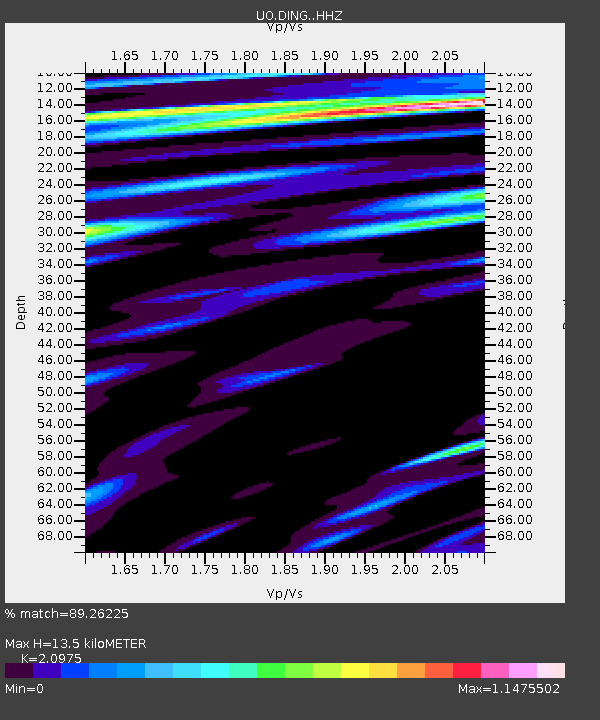
| Estimated Moho Depth: |
13.5 km |
| Estimated Crust Vp/Vs: |
2.10 |
| Assumed Crust Vp: |
6.048 km/s |
| Estimated Crust Vs: |
2.883 km/s |
| Estimated Crust Poisson's Ratio: |
0.35 |
|
| Radial Match: |
89.26225 % |
| Radial Bump: |
400 |
| Transverse Match: |
76.49862 % |
| Transverse Bump: |
400 |
| SOD ConfigId: |
31937991 |
| Insert Time: |
2023-08-22 19:01:40.801 +0000 |
| GWidth: |
2.5 |
| Max Bumps: |
400 |
| Tol: |
0.001 |
|

Signal To Noise
| Channel | StoN | STA | LTA |
| UO:DING: :HHZ:20230808T18:49:41.719971Z | 0.96830785 | 1.7279875E-7 | 1.7845436E-7 |
| UO:DING: :HHN:20230808T18:49:41.719971Z | 1.1164199 | 2.5021455E-7 | 2.2412226E-7 |
| UO:DING: :HHE:20230808T18:49:41.719971Z | 0.99350524 | 2.0514845E-7 | 2.0648956E-7 |
| Arrivals |
| Ps | 2.5 SECOND |
| PpPs | 6.7 SECOND |
| PsPs/PpSs | 9.3 SECOND |


