You are here: Home > Network List > US - United States National Seismic Network Stations List
> Station SDCO Great Sand Dunes National Park, Colorado, USA > Earthquake Result Viewer
SDCO Great Sand Dunes National Park, Colorado, USA - Earthquake Result Viewer
| Earthquake location: |
Tonga Islands |
| Earthquake latitude/longitude: |
-15.0/-173.0 |
| Earthquake time(UTC): |
2023/08/08 (220) 18:38:56 GMT |
| Earthquake Depth: |
120 km |
| Earthquake Magnitude: |
6.2 Mi |
| Earthquake Catalog/Contributor: |
NEIC PDE/pt |
|
| Network: |
US United States National Seismic Network |
| Station: |
SDCO Great Sand Dunes National Park, Colorado, USA |
| Lat/Lon: |
37.75 N/105.50 W |
| Elevation: |
2569 m |
|
| Distance: |
82.2 deg |
| Az: |
47.67 deg |
| Baz: |
244.316 deg |
| Ray Param: |
0.04681076 |
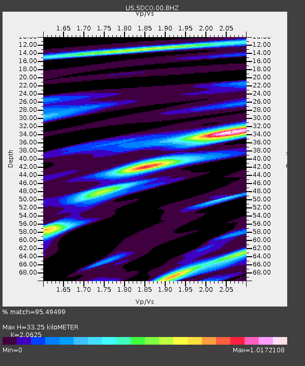
| Estimated Moho Depth: |
33.25 km |
| Estimated Crust Vp/Vs: |
2.06 |
| Assumed Crust Vp: |
6.316 km/s |
| Estimated Crust Vs: |
3.062 km/s |
| Estimated Crust Poisson's Ratio: |
0.35 |
|
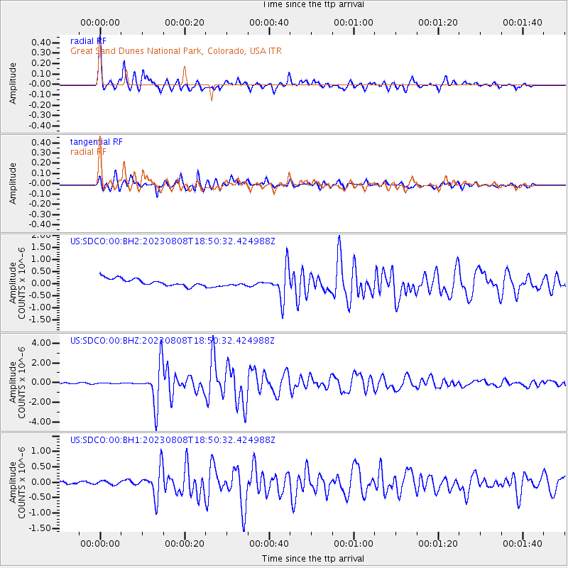
| Radial Match: |
95.49499 % |
| Radial Bump: |
371 |
| Transverse Match: |
86.26514 % |
| Transverse Bump: |
400 |
| SOD ConfigId: |
31937991 |
| Insert Time: |
2023-08-22 19:02:53.850 +0000 |
| GWidth: |
2.5 |
| Max Bumps: |
400 |
| Tol: |
0.001 |
|
Signal To Noise
| Channel | StoN | STA | LTA |
| US:SDCO:00:BHZ:20230808T18:50:32.424988Z | 0.54474175 | 3.725109E-8 | 6.838303E-8 |
| US:SDCO:00:BH1:20230808T18:50:32.424988Z | 1.0076987 | 8.879556E-8 | 8.811717E-8 |
| US:SDCO:00:BH2:20230808T18:50:32.424988Z | 0.8479059 | 1.2225016E-7 | 1.4417891E-7 |
| Arrivals |
| Ps | 5.7 SECOND |
| PpPs | 16 SECOND |
| PsPs/PpSs | 21 SECOND |


