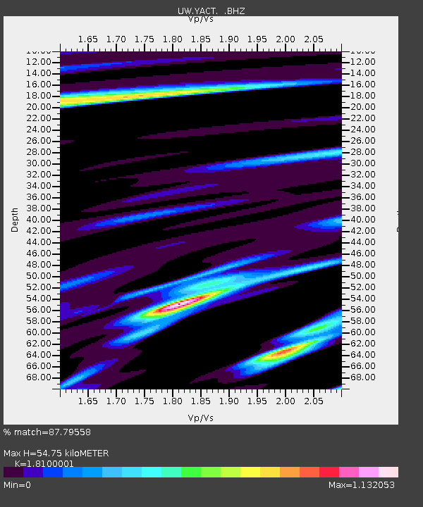
YACT Amboy, WA, USA - Earthquake Result Viewer

Earthquake location: Near East Coast Of Honshu, Japan
Earthquake latitude/longitude: 39.7/142.4
Earthquake time(UTC): 2010/07/04 (185) 21:55:51 GMT
Earthquake Depth: 27 km
Earthquake Magnitude: 6.4 MB, 6.1 MS, 6.3 MW, 6.2 MW
Earthquake Catalog/Contributor: WHDF/NEIC
Network: UW Pacific Northwest Regional Seismic Network
Station: YACT Amboy, WA, USA
Lat/Lon: 45.93 N/122.42 W
Elevation: 211 m
Distance: 66.0 deg
Az: 49.534 deg
Baz: 302.749 deg
Ray Param: 0.057864025
Estimated Moho Depth: 54.75 km
Estimated Crust Vp/Vs: 1.81
Assumed Crust Vp: 6.566 km/s
Estimated Crust Vs: 3.628 km/s
Estimated Crust Poisson's Ratio: 0.28
Radial Match: 87.79558 %
Radial Bump: 400
Transverse Match: 86.08002 %
Transverse Bump: 400
SOD ConfigId: 319893
Insert Time: 2011-01-05 00:46:34.420 +0000
GWidth: 2.5
Max Bumps: 400
Tol: 0.001

Signal To Noise

ChannelStoNSTALTA
UW:YACT: :BHZ:20100704T22:06:04.974995Z7.4622219.655699E-71.2939444E-7
UW:YACT: :BHN:20100704T22:06:04.974995Z3.3394263.087405E-79.245316E-8
UW:YACT: :BHE:20100704T22:06:04.974995Z4.34971143.5581135E-78.180113E-8
Arrivals
Ps7.0 SECOND
PpPs22 SECOND
PsPs/PpSs30 SECOND