MRBL Marblemount, WA, USA - Earthquake Result Viewer
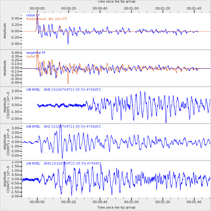
Earthquake location: Near East Coast Of Honshu, Japan
Earthquake latitude/longitude: 39.7/142.4
Earthquake time(UTC): 2010/07/04 (185) 21:55:51 GMT
Earthquake Depth: 27 km
Earthquake Magnitude: 6.4 MB, 6.1 MS, 6.3 MW, 6.2 MW
Earthquake Catalog/Contributor: WHDF/NEIC
Network: UW Pacific Northwest Regional Seismic Network
Station: MRBL Marblemount, WA, USA
Lat/Lon: 48.52 N/121.48 W
Elevation: 75 m
Distance: 65.1 deg
Az: 46.762 deg
Baz: 302.287 deg
Ray Param: 0.058423895
Estimated Moho Depth: 40.25 km
Estimated Crust Vp/Vs: 1.66
Assumed Crust Vp: 6.566 km/s
Estimated Crust Vs: 3.944 km/s
Estimated Crust Poisson's Ratio: 0.22
Radial Match: 90.06995 %
Radial Bump: 400
Transverse Match: 87.74552 %
Transverse Bump: 400
SOD ConfigId: 319893
Insert Time: 2011-01-05 00:46:34.786 +0000
GWidth: 2.5
Max Bumps: 400
Tol: 0.001

Signal To Noise

ChannelStoNSTALTA
UW:MRBL: :BHZ:20100704T22:05:59.474995Z10.5268399.121375E-78.6648754E-8
UW:MRBL: :BHN:20100704T22:05:59.474995Z2.83099482.7713205E-79.7892105E-8
UW:MRBL: :BHE:20100704T22:05:59.474995Z2.73099923.3553718E-71.2286242E-7
Arrivals
Ps4.3 SECOND
PpPs16 SECOND
PsPs/PpSs20 SECOND