You are here: Home > Network List > UW - Pacific Northwest Regional Seismic Network Stations List
> Station OMAK Colville Reservation, Omak, WA, USA > Earthquake Result Viewer
OMAK Colville Reservation, Omak, WA, USA - Earthquake Result Viewer
| Earthquake location: |
Near East Coast Of Honshu, Japan |
| Earthquake latitude/longitude: |
39.7/142.4 |
| Earthquake time(UTC): |
2010/07/04 (185) 21:55:51 GMT |
| Earthquake Depth: |
27 km |
| Earthquake Magnitude: |
6.4 MB, 6.1 MS, 6.3 MW, 6.2 MW |
| Earthquake Catalog/Contributor: |
WHDF/NEIC |
|
| Network: |
UW Pacific Northwest Regional Seismic Network |
| Station: |
OMAK Colville Reservation, Omak, WA, USA |
| Lat/Lon: |
48.36 N/119.33 W |
| Elevation: |
696 m |
|
| Distance: |
66.4 deg |
| Az: |
46.055 deg |
| Baz: |
303.602 deg |
| Ray Param: |
0.057579245 |
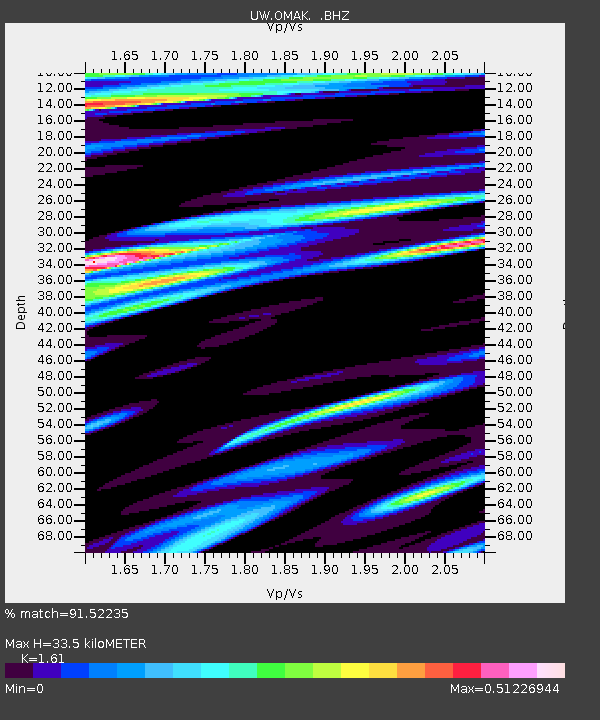
| Estimated Moho Depth: |
33.5 km |
| Estimated Crust Vp/Vs: |
1.61 |
| Assumed Crust Vp: |
6.419 km/s |
| Estimated Crust Vs: |
3.987 km/s |
| Estimated Crust Poisson's Ratio: |
0.19 |
|
| Radial Match: |
91.52235 % |
| Radial Bump: |
400 |
| Transverse Match: |
80.29228 % |
| Transverse Bump: |
400 |
| SOD ConfigId: |
319893 |
| Insert Time: |
2011-01-05 00:46:47.849 +0000 |
| GWidth: |
2.5 |
| Max Bumps: |
400 |
| Tol: |
0.001 |
|

Signal To Noise
| Channel | StoN | STA | LTA |
| UW:OMAK: :BHZ:20100704T22:06:07.75002Z | 14.136741 | 1.0485768E-6 | 7.4173876E-8 |
| UW:OMAK: :BHN:20100704T22:06:07.75002Z | 2.413294 | 2.195821E-7 | 9.0988536E-8 |
| UW:OMAK: :BHE:20100704T22:06:07.75002Z | 6.126851 | 4.1452333E-7 | 6.765683E-8 |
| Arrivals |
| Ps | 3.3 SECOND |
| PpPs | 13 SECOND |
| PsPs/PpSs | 16 SECOND |


