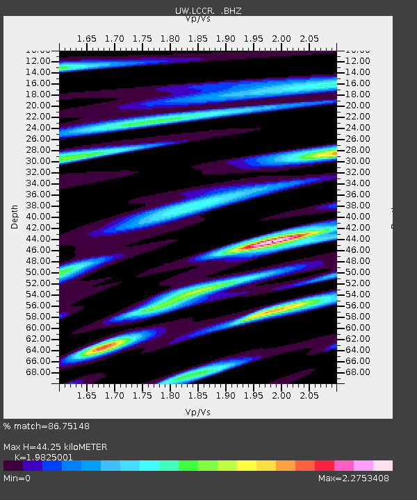
LCCR Mulino, OR, USA - Earthquake Result Viewer
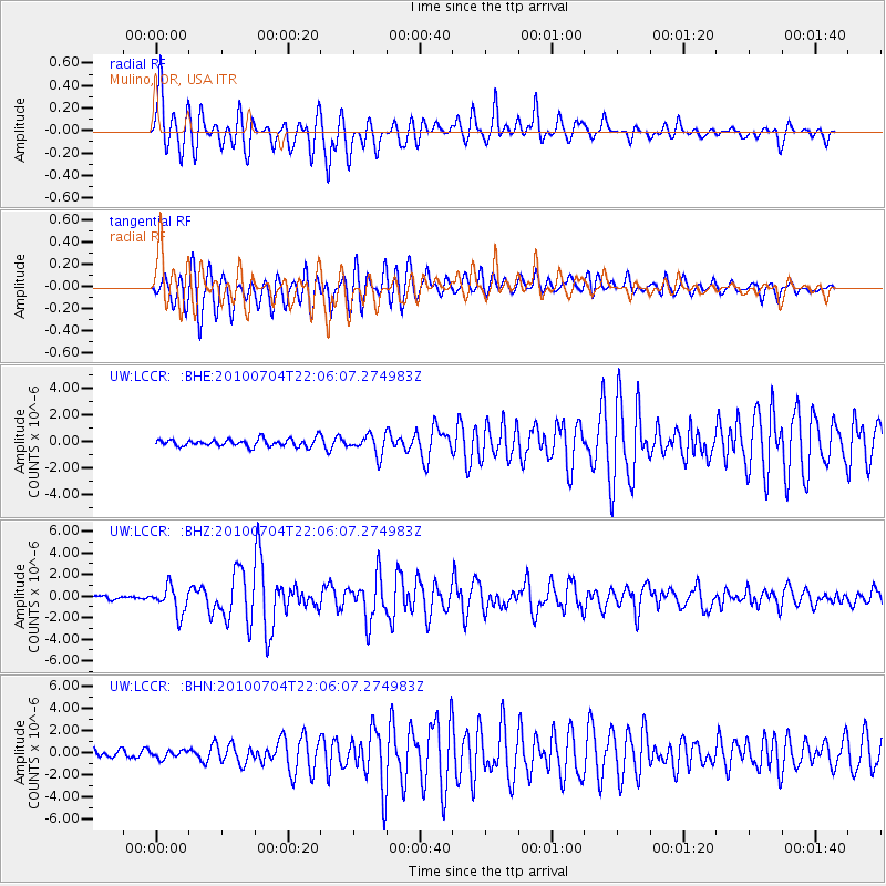
Earthquake location: Near East Coast Of Honshu, Japan
Earthquake latitude/longitude: 39.7/142.4
Earthquake time(UTC): 2010/07/04 (185) 21:55:51 GMT
Earthquake Depth: 27 km
Earthquake Magnitude: 6.4 MB, 6.1 MS, 6.3 MW, 6.2 MW
Earthquake Catalog/Contributor: WHDF/NEIC
Network: UW Pacific Northwest Regional Seismic Network
Station: LCCR Mulino, OR, USA
Lat/Lon: 45.21 N/122.48 W
Elevation: 273 m
Distance: 66.4 deg
Az: 50.226 deg
Baz: 302.986 deg
Ray Param: 0.057629023
Estimated Moho Depth: 44.25 km
Estimated Crust Vp/Vs: 1.98
Assumed Crust Vp: 6.566 km/s
Estimated Crust Vs: 3.312 km/s
Estimated Crust Poisson's Ratio: 0.33
Radial Match: 86.75148 %
Radial Bump: 400
Transverse Match: 82.843765 %
Transverse Bump: 400
SOD ConfigId: 319893
Insert Time: 2011-01-05 00:46:48.081 +0000
GWidth: 2.5
Max Bumps: 400
Tol: 0.001

Signal To Noise

ChannelStoNSTALTA
UW:LCCR: :BHZ:20100704T22:06:07.274983Z5.91617731.2503072E-62.11337E-7
UW:LCCR: :BHN:20100704T22:06:07.274983Z1.22887993.414364E-72.7784358E-7
UW:LCCR: :BHE:20100704T22:06:07.274983Z2.6618247.465985E-72.8048382E-7
Arrivals
Ps6.9 SECOND
PpPs19 SECOND
PsPs/PpSs26 SECOND