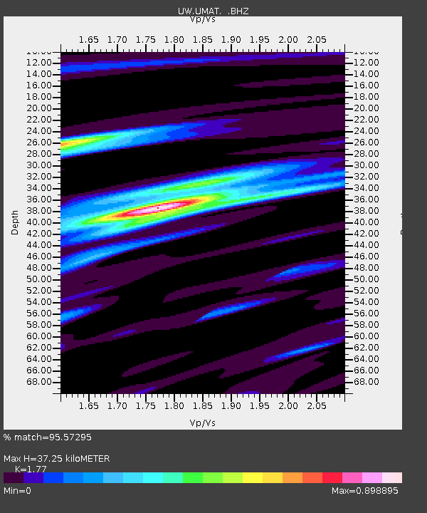
UMAT Pilot Rock, OR, USA - Earthquake Result Viewer

Earthquake location: Near East Coast Of Honshu, Japan
Earthquake latitude/longitude: 39.7/142.4
Earthquake time(UTC): 2010/07/04 (185) 21:55:51 GMT
Earthquake Depth: 27 km
Earthquake Magnitude: 6.4 MB, 6.1 MS, 6.3 MW, 6.2 MW
Earthquake Catalog/Contributor: WHDF/NEIC
Network: UW Pacific Northwest Regional Seismic Network
Station: UMAT Pilot Rock, OR, USA
Lat/Lon: 45.29 N/118.96 W
Elevation: 1318 m
Distance: 68.4 deg
Az: 48.647 deg
Baz: 304.87 deg
Ray Param: 0.056307368
Estimated Moho Depth: 37.25 km
Estimated Crust Vp/Vs: 1.77
Assumed Crust Vp: 6.571 km/s
Estimated Crust Vs: 3.712 km/s
Estimated Crust Poisson's Ratio: 0.27
Radial Match: 95.57295 %
Radial Bump: 336
Transverse Match: 90.5563 %
Transverse Bump: 400
SOD ConfigId: 319893
Insert Time: 2011-01-05 00:47:11.395 +0000
GWidth: 2.5
Max Bumps: 400
Tol: 0.001

Signal To Noise

ChannelStoNSTALTA
UW:UMAT: :BHZ:20100704T22:06:20.00002Z10.861978.2324976E-77.579194E-8
UW:UMAT: :BHN:20100704T22:06:20.00002Z4.20220231.2602686E-72.9990673E-8
UW:UMAT: :BHE:20100704T22:06:20.00002Z5.51075123.3179612E-76.020887E-8
Arrivals
Ps4.5 SECOND
PpPs15 SECOND
PsPs/PpSs20 SECOND