You are here: Home > Network List > PF - Volcanologic Network of Piton de Fournaise-OVPF Stations List
> Station FRE Station Sismologique des Fonds de la Riviere de l'Est > Earthquake Result Viewer
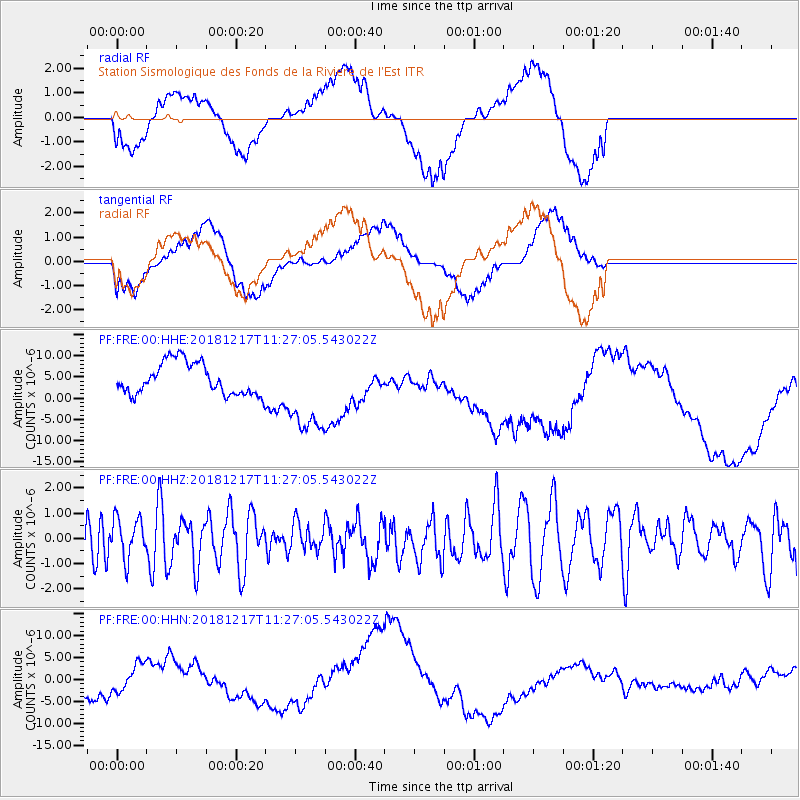
FRE Station Sismologique des Fonds de la Riviere de l'Est - Earthquake Result Viewer
*The percent match for this event was below the threshold and hence no stack was calculated.
| Earthquake location: |
New Britain Region, P.N.G. |
| Earthquake latitude/longitude: |
-5.0/152.3 |
| Earthquake time(UTC): |
2018/12/17 (351) 11:14:23 GMT |
| Earthquake Depth: |
60 km |
| Earthquake Magnitude: |
5.5 mb |
| Earthquake Catalog/Contributor: |
NEIC PDE/us |
|
| Network: |
PF Volcanologic Network of Piton de Fournaise-OVPF |
| Station: |
FRE Station Sismologique des Fonds de la Riviere de l'Est |
| Lat/Lon: |
21.20 S/55.70 E |
| Elevation: |
1775 m |
|
| Distance: |
94.4 deg |
| Az: |
248.368 deg |
| Baz: |
97.069 deg |
| Ray Param: |
$rayparam |
*The percent match for this event was below the threshold and hence was not used in the summary stack. |
|
| Radial Match: |
36.51912 % |
| Radial Bump: |
400 |
| Transverse Match: |
45.934513 % |
| Transverse Bump: |
400 |
| SOD ConfigId: |
3201911 |
| Insert Time: |
2018-12-31 11:19:41.572 +0000 |
| GWidth: |
2.5 |
| Max Bumps: |
400 |
| Tol: |
0.001 |
|
Signal To Noise
| Channel | StoN | STA | LTA |
| PF:FRE:00:HHZ:20181217T11:27:05.543022Z | 0.8673211 | 8.0775715E-7 | 9.313242E-7 |
| PF:FRE:00:HHN:20181217T11:27:05.543022Z | 0.7040934 | 2.9728344E-6 | 4.222216E-6 |
| PF:FRE:00:HHE:20181217T11:27:05.543022Z | 2.692769 | 1.0109497E-5 | 3.7543132E-6 |
| Arrivals |
| Ps | |
| PpPs | |
| PsPs/PpSs | |


