You are here: Home > Network List > US - United States National Seismic Network Stations List
> Station BLA Blacksburg, Virginia, USA > Earthquake Result Viewer
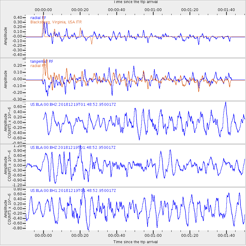
BLA Blacksburg, Virginia, USA - Earthquake Result Viewer
*The percent match for this event was below the threshold and hence no stack was calculated.
| Earthquake location: |
Southeast Of Easter Island |
| Earthquake latitude/longitude: |
-36.1/-101.0 |
| Earthquake time(UTC): |
2018/12/19 (353) 01:37:40 GMT |
| Earthquake Depth: |
10 km |
| Earthquake Magnitude: |
6.2 Mww |
| Earthquake Catalog/Contributor: |
NEIC PDE/us |
|
| Network: |
US United States National Seismic Network |
| Station: |
BLA Blacksburg, Virginia, USA |
| Lat/Lon: |
37.21 N/80.42 W |
| Elevation: |
634 m |
|
| Distance: |
75.4 deg |
| Az: |
16.871 deg |
| Baz: |
197.117 deg |
| Ray Param: |
$rayparam |
*The percent match for this event was below the threshold and hence was not used in the summary stack. |
|
| Radial Match: |
50.292767 % |
| Radial Bump: |
400 |
| Transverse Match: |
53.137123 % |
| Transverse Bump: |
382 |
| SOD ConfigId: |
3201911 |
| Insert Time: |
2019-01-02 01:58:06.356 +0000 |
| GWidth: |
2.5 |
| Max Bumps: |
400 |
| Tol: |
0.001 |
|
Signal To Noise
| Channel | StoN | STA | LTA |
| US:BLA:00:BHZ:20181219T01:48:52.950017Z | 2.4920187 | 5.5432855E-7 | 2.2244159E-7 |
| US:BLA:00:BH1:20181219T01:48:52.950017Z | 1.1415669 | 2.803531E-7 | 2.4558622E-7 |
| US:BLA:00:BH2:20181219T01:48:52.950017Z | 0.8495684 | 1.8060251E-7 | 2.1258148E-7 |
| Arrivals |
| Ps | |
| PpPs | |
| PsPs/PpSs | |


