You are here: Home > Network List > CI - Caltech Regional Seismic Network Stations List
> Station RCT Rector, Visalia, CA, USA > Earthquake Result Viewer
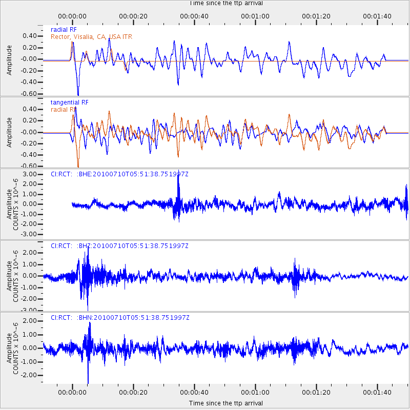
RCT Rector, Visalia, CA, USA - Earthquake Result Viewer
*The percent match for this event was below the threshold and hence no stack was calculated.
| Earthquake location: |
Mariana Islands |
| Earthquake latitude/longitude: |
14.0/145.0 |
| Earthquake time(UTC): |
2010/07/10 (191) 05:39:43 GMT |
| Earthquake Depth: |
136 km |
| Earthquake Magnitude: |
5.6 MB, 5.6 MW, 5.5 MW |
| Earthquake Catalog/Contributor: |
WHDF/NEIC |
|
| Network: |
CI Caltech Regional Seismic Network |
| Station: |
RCT Rector, Visalia, CA, USA |
| Lat/Lon: |
36.31 N/119.24 W |
| Elevation: |
107 m |
|
| Distance: |
86.4 deg |
| Az: |
53.644 deg |
| Baz: |
284.59 deg |
| Ray Param: |
$rayparam |
*The percent match for this event was below the threshold and hence was not used in the summary stack. |
|
| Radial Match: |
61.37454 % |
| Radial Bump: |
400 |
| Transverse Match: |
66.030975 % |
| Transverse Bump: |
400 |
| SOD ConfigId: |
319893 |
| Insert Time: |
2011-01-05 01:02:39.406 +0000 |
| GWidth: |
2.5 |
| Max Bumps: |
400 |
| Tol: |
0.001 |
|
Signal To Noise
| Channel | StoN | STA | LTA |
| CI:RCT: :BHZ:20100710T05:51:38.751997Z | 5.3648844 | 7.421788E-7 | 1.3834013E-7 |
| CI:RCT: :BHN:20100710T05:51:38.751997Z | 2.287651 | 3.6584706E-7 | 1.5992258E-7 |
| CI:RCT: :BHE:20100710T05:51:38.751997Z | 2.5631049 | 5.178294E-7 | 2.0203208E-7 |
| Arrivals |
| Ps | |
| PpPs | |
| PsPs/PpSs | |


