You are here: Home > Network List > UW - Pacific Northwest Regional Seismic Network Stations List
> Station ETW Entiat, WA, USA > Earthquake Result Viewer
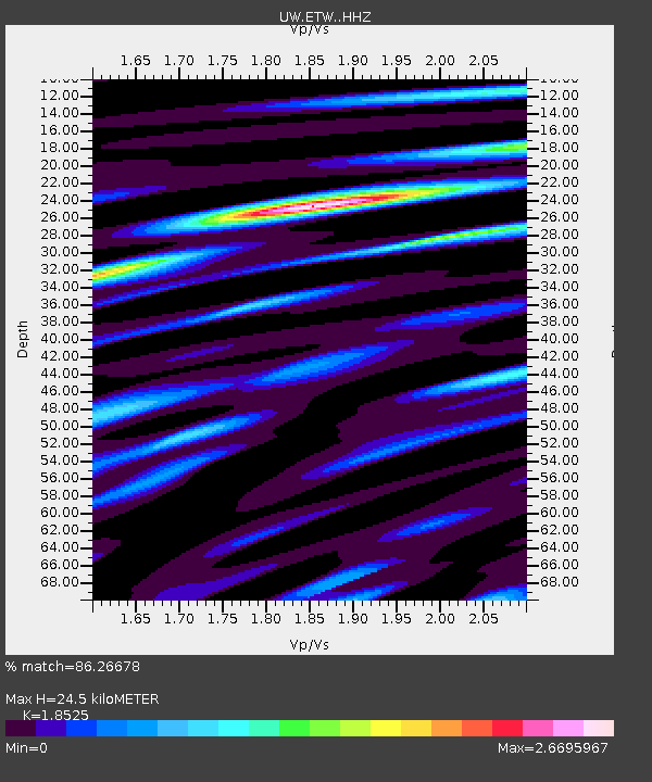
ETW Entiat, WA, USA - Earthquake Result Viewer
| Earthquake location: |
Chiapas, Mexico |
| Earthquake latitude/longitude: |
16.2/-93.6 |
| Earthquake time(UTC): |
2023/08/09 (221) 09:33:26 GMT |
| Earthquake Depth: |
111 km |
| Earthquake Magnitude: |
5.8 mww |
| Earthquake Catalog/Contributor: |
NEIC PDE/us |
|
| Network: |
UW Pacific Northwest Regional Seismic Network |
| Station: |
ETW Entiat, WA, USA |
| Lat/Lon: |
47.60 N/120.33 W |
| Elevation: |
1469 m |
|
| Distance: |
38.3 deg |
| Az: |
330.575 deg |
| Baz: |
135.766 deg |
| Ray Param: |
0.075276665 |
| Estimated Moho Depth: |
24.5 km |
| Estimated Crust Vp/Vs: |
1.85 |
| Assumed Crust Vp: |
6.597 km/s |
| Estimated Crust Vs: |
3.561 km/s |
| Estimated Crust Poisson's Ratio: |
0.29 |
|
| Radial Match: |
86.26678 % |
| Radial Bump: |
297 |
| Transverse Match: |
77.71299 % |
| Transverse Bump: |
400 |
| SOD ConfigId: |
31937991 |
| Insert Time: |
2023-08-23 10:10:45.570 +0000 |
| GWidth: |
2.5 |
| Max Bumps: |
400 |
| Tol: |
0.001 |
|

Signal To Noise
| Channel | StoN | STA | LTA |
| UW:ETW: :HHZ:20230809T09:40:06.180007Z | 22.70647 | 1.6611205E-6 | 7.315626E-8 |
| UW:ETW: :HHN:20230809T09:40:06.180007Z | 25.85194 | 1.7206744E-6 | 6.655881E-8 |
| UW:ETW: :HHE:20230809T09:40:06.180007Z | 14.098464 | 8.369618E-7 | 5.936546E-8 |
| Arrivals |
| Ps | 3.4 SECOND |
| PpPs | 9.9 SECOND |
| PsPs/PpSs | 13 SECOND |


