You are here: Home > Network List > UW - Pacific Northwest Regional Seismic Network Stations List
> Station LMONT Lamont School, Lamont, WA, USA > Earthquake Result Viewer
LMONT Lamont School, Lamont, WA, USA - Earthquake Result Viewer
| Earthquake location: |
Chiapas, Mexico |
| Earthquake latitude/longitude: |
16.2/-93.6 |
| Earthquake time(UTC): |
2023/08/09 (221) 09:33:26 GMT |
| Earthquake Depth: |
111 km |
| Earthquake Magnitude: |
5.8 mww |
| Earthquake Catalog/Contributor: |
NEIC PDE/us |
|
| Network: |
UW Pacific Northwest Regional Seismic Network |
| Station: |
LMONT Lamont School, Lamont, WA, USA |
| Lat/Lon: |
47.20 N/117.90 W |
| Elevation: |
598 m |
|
| Distance: |
36.9 deg |
| Az: |
332.118 deg |
| Baz: |
138.773 deg |
| Ray Param: |
0.07606506 |
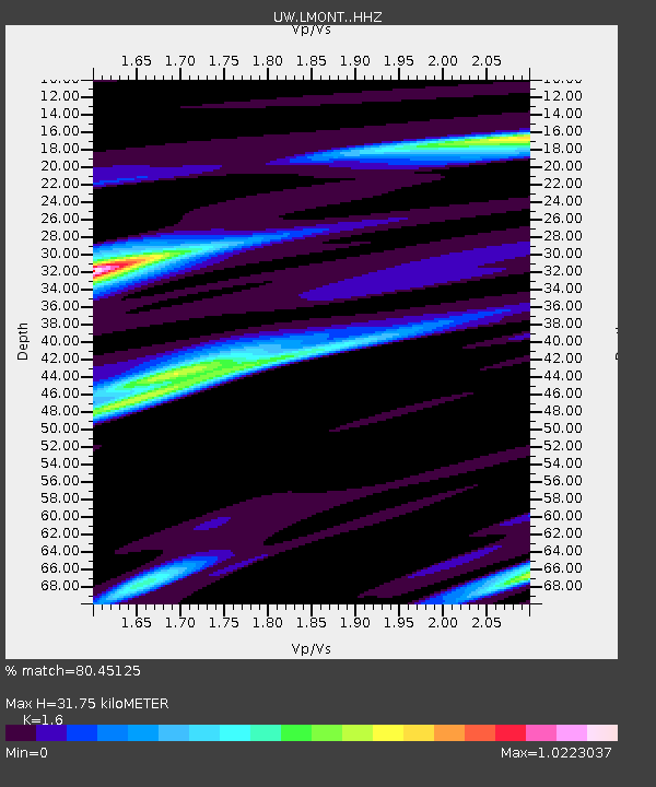
| Estimated Moho Depth: |
31.75 km |
| Estimated Crust Vp/Vs: |
1.60 |
| Assumed Crust Vp: |
6.571 km/s |
| Estimated Crust Vs: |
4.107 km/s |
| Estimated Crust Poisson's Ratio: |
0.18 |
|
| Radial Match: |
80.45125 % |
| Radial Bump: |
313 |
| Transverse Match: |
60.46482 % |
| Transverse Bump: |
400 |
| SOD ConfigId: |
31937991 |
| Insert Time: |
2023-08-23 10:11:41.945 +0000 |
| GWidth: |
2.5 |
| Max Bumps: |
400 |
| Tol: |
0.001 |
|

Signal To Noise
| Channel | StoN | STA | LTA |
| UW:LMONT: :HHZ:20230809T09:39:54.270003Z | 15.895411 | 1.0737168E-6 | 6.7548854E-8 |
| UW:LMONT: :HHN:20230809T09:39:54.270003Z | 5.4110413 | 5.8613676E-7 | 1.0832236E-7 |
| UW:LMONT: :HHE:20230809T09:39:54.270003Z | 8.688859 | 5.9790926E-7 | 6.881333E-8 |
| Arrivals |
| Ps | 3.2 SECOND |
| PpPs | 12 SECOND |
| PsPs/PpSs | 15 SECOND |


