You are here: Home > Network List > UW - Pacific Northwest Regional Seismic Network Stations List
> Station VFP Flag Point, OR, USA > Earthquake Result Viewer
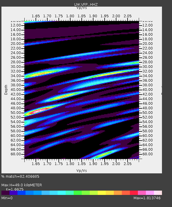
VFP Flag Point, OR, USA - Earthquake Result Viewer
| Earthquake location: |
Chiapas, Mexico |
| Earthquake latitude/longitude: |
16.2/-93.6 |
| Earthquake time(UTC): |
2023/08/09 (221) 09:33:26 GMT |
| Earthquake Depth: |
111 km |
| Earthquake Magnitude: |
5.8 mww |
| Earthquake Catalog/Contributor: |
NEIC PDE/us |
|
| Network: |
UW Pacific Northwest Regional Seismic Network |
| Station: |
VFP Flag Point, OR, USA |
| Lat/Lon: |
45.32 N/121.47 W |
| Elevation: |
1722 m |
|
| Distance: |
37.3 deg |
| Az: |
327.001 deg |
| Baz: |
132.122 deg |
| Ray Param: |
0.07584003 |
| Estimated Moho Depth: |
49.0 km |
| Estimated Crust Vp/Vs: |
1.66 |
| Assumed Crust Vp: |
6.597 km/s |
| Estimated Crust Vs: |
3.968 km/s |
| Estimated Crust Poisson's Ratio: |
0.22 |
|
| Radial Match: |
82.406685 % |
| Radial Bump: |
400 |
| Transverse Match: |
73.0134 % |
| Transverse Bump: |
400 |
| SOD ConfigId: |
31937991 |
| Insert Time: |
2023-08-23 10:13:33.409 +0000 |
| GWidth: |
2.5 |
| Max Bumps: |
400 |
| Tol: |
0.001 |
|

Signal To Noise
| Channel | StoN | STA | LTA |
| UW:VFP: :HHZ:20230809T09:39:57.59001Z | 33.633617 | 1.9275687E-6 | 5.7310775E-8 |
| UW:VFP: :HHN:20230809T09:39:57.59001Z | 9.578881 | 9.21643E-7 | 9.621614E-8 |
| UW:VFP: :HHE:20230809T09:39:57.59001Z | 9.186613 | 9.354238E-7 | 1.01824675E-7 |
| Arrivals |
| Ps | 5.3 SECOND |
| PpPs | 18 SECOND |
| PsPs/PpSs | 24 SECOND |


