You are here: Home > Network List > AG - Arkansas Seismic Network Stations List
> Station U40A Yellville, AR > Earthquake Result Viewer
U40A Yellville, AR - Earthquake Result Viewer
| Earthquake location: |
Komandorskiye Ostrova Region |
| Earthquake latitude/longitude: |
54.8/164.8 |
| Earthquake time(UTC): |
2018/12/20 (354) 17:01:56 GMT |
| Earthquake Depth: |
33 km |
| Earthquake Magnitude: |
7.3 Mi |
| Earthquake Catalog/Contributor: |
NEIC PDE/pt |
|
| Network: |
AG Arkansas Seismic Network |
| Station: |
U40A Yellville, AR |
| Lat/Lon: |
36.36 N/92.85 W |
| Elevation: |
374 m |
|
| Distance: |
67.5 deg |
| Az: |
58.576 deg |
| Baz: |
322.314 deg |
| Ray Param: |
0.056833316 |
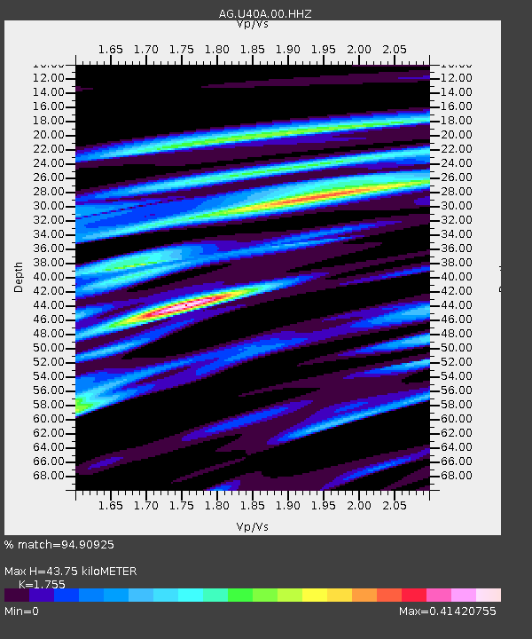
| Estimated Moho Depth: |
43.75 km |
| Estimated Crust Vp/Vs: |
1.75 |
| Assumed Crust Vp: |
6.53 km/s |
| Estimated Crust Vs: |
3.721 km/s |
| Estimated Crust Poisson's Ratio: |
0.26 |
|
| Radial Match: |
94.90925 % |
| Radial Bump: |
322 |
| Transverse Match: |
79.32359 % |
| Transverse Bump: |
400 |
| SOD ConfigId: |
3201911 |
| Insert Time: |
2019-01-03 17:10:56.797 +0000 |
| GWidth: |
2.5 |
| Max Bumps: |
400 |
| Tol: |
0.001 |
|

Signal To Noise
| Channel | StoN | STA | LTA |
| AG:U40A:00:HHZ:20181220T17:12:18.169983Z | 7.435382 | 3.6135095E-6 | 4.8598844E-7 |
| AG:U40A:00:HHN:20181220T17:12:18.169983Z | 3.4004042 | 1.4724616E-6 | 4.3302543E-7 |
| AG:U40A:00:HHE:20181220T17:12:18.169983Z | 2.8068218 | 9.1887006E-7 | 3.273703E-7 |
| Arrivals |
| Ps | 5.3 SECOND |
| PpPs | 18 SECOND |
| PsPs/PpSs | 23 SECOND |


