You are here: Home > Network List > AV - Alaska Volcano Observatory Stations List
> Station KEL Katmai Kelez, Alaska > Earthquake Result Viewer
KEL Katmai Kelez, Alaska - Earthquake Result Viewer
| Earthquake location: |
Hokkaido, Japan Region |
| Earthquake latitude/longitude: |
41.1/142.8 |
| Earthquake time(UTC): |
2023/08/11 (223) 00:14:32 GMT |
| Earthquake Depth: |
30 km |
| Earthquake Magnitude: |
5.9 mww |
| Earthquake Catalog/Contributor: |
NEIC PDE/us |
|
| Network: |
AV Alaska Volcano Observatory |
| Station: |
KEL Katmai Kelez, Alaska |
| Lat/Lon: |
58.44 N/155.74 W |
| Elevation: |
975 m |
|
| Distance: |
41.6 deg |
| Az: |
44.034 deg |
| Baz: |
273.203 deg |
| Ray Param: |
0.073609635 |
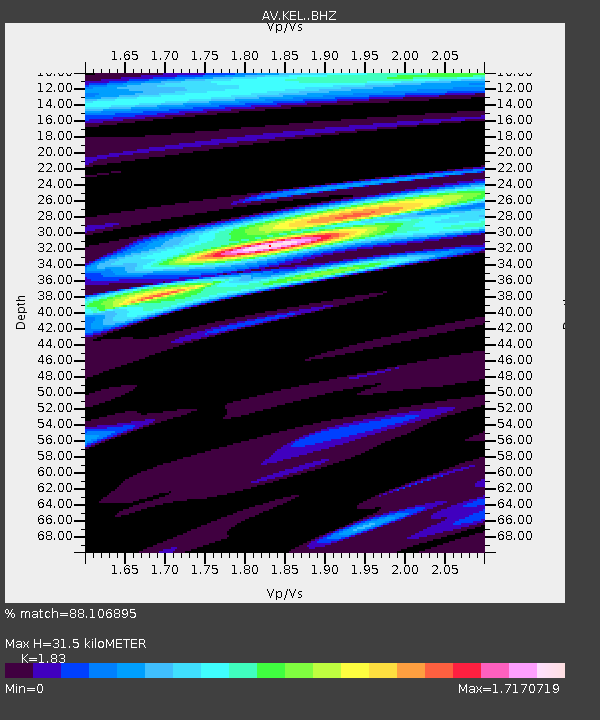
| Estimated Moho Depth: |
31.5 km |
| Estimated Crust Vp/Vs: |
1.83 |
| Assumed Crust Vp: |
6.438 km/s |
| Estimated Crust Vs: |
3.518 km/s |
| Estimated Crust Poisson's Ratio: |
0.29 |
|
| Radial Match: |
88.106895 % |
| Radial Bump: |
400 |
| Transverse Match: |
71.730286 % |
| Transverse Bump: |
400 |
| SOD ConfigId: |
31937991 |
| Insert Time: |
2023-08-25 00:23:49.114 +0000 |
| GWidth: |
2.5 |
| Max Bumps: |
400 |
| Tol: |
0.001 |
|

Signal To Noise
| Channel | StoN | STA | LTA |
| AV:KEL: :BHZ:20230811T00:21:47.880Z | 2.8703616 | 3.092363E-7 | 1.0773427E-7 |
| AV:KEL: :BHN:20230811T00:21:47.880Z | 1.4083449 | 1.2140248E-7 | 8.620224E-8 |
| AV:KEL: :BHE:20230811T00:21:47.880Z | 2.164579 | 1.9154683E-7 | 8.84915E-8 |
| Arrivals |
| Ps | 4.3 SECOND |
| PpPs | 13 SECOND |
| PsPs/PpSs | 17 SECOND |


