You are here: Home > Network List > BK - Berkeley Digital Seismograph Network Stations List
> Station CMB Columbia College, Columbia, CA > Earthquake Result Viewer
CMB Columbia College, Columbia, CA - Earthquake Result Viewer

| Earthquake location: |
Komandorskiye Ostrova Region |
| Earthquake latitude/longitude: |
54.8/164.8 |
| Earthquake time(UTC): |
2018/12/20 (354) 17:01:56 GMT |
| Earthquake Depth: |
33 km |
| Earthquake Magnitude: |
7.3 Mi |
| Earthquake Catalog/Contributor: |
NEIC PDE/pt |
|
| Network: |
BK Berkeley Digital Seismograph Network |
| Station: |
CMB Columbia College, Columbia, CA |
| Lat/Lon: |
38.03 N/120.39 W |
| Elevation: |
697 m |
|
| Distance: |
51.7 deg |
| Az: |
76.297 deg |
| Baz: |
314.64 deg |
| Ray Param: |
0.067208596 |
| Estimated Moho Depth: |
17.5 km |
| Estimated Crust Vp/Vs: |
1.60 |
| Assumed Crust Vp: |
6.597 km/s |
| Estimated Crust Vs: |
4.123 km/s |
| Estimated Crust Poisson's Ratio: |
0.18 |
|
| Radial Match: |
97.702415 % |
| Radial Bump: |
400 |
| Transverse Match: |
90.72012 % |
| Transverse Bump: |
400 |
| SOD ConfigId: |
3201911 |
| Insert Time: |
2019-01-03 17:11:40.783 +0000 |
| GWidth: |
2.5 |
| Max Bumps: |
400 |
| Tol: |
0.001 |
|
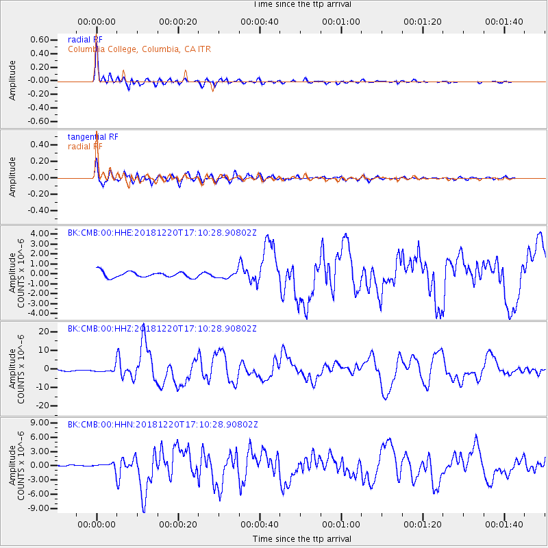
Signal To Noise
| Channel | StoN | STA | LTA |
| BK:CMB:00:HHZ:20181220T17:10:28.90802Z | 3.767306 | 1.3886181E-6 | 3.6859709E-7 |
| BK:CMB:00:HHN:20181220T17:10:28.90802Z | 3.0674517 | 6.256503E-7 | 2.0396418E-7 |
| BK:CMB:00:HHE:20181220T17:10:28.90802Z | 1.0967058 | 3.1847512E-7 | 2.9039248E-7 |
| Arrivals |
| Ps | 1.7 SECOND |
| PpPs | 6.5 SECOND |
| PsPs/PpSs | 8.2 SECOND |


