You are here: Home > Network List > AV - Alaska Volcano Observatory Stations List
> Station SPCN Ckakachatna North Broadband, Mount Spurr, Alaska > Earthquake Result Viewer
SPCN Ckakachatna North Broadband, Mount Spurr, Alaska - Earthquake Result Viewer
| Earthquake location: |
Hokkaido, Japan Region |
| Earthquake latitude/longitude: |
41.1/142.8 |
| Earthquake time(UTC): |
2023/08/11 (223) 00:14:32 GMT |
| Earthquake Depth: |
30 km |
| Earthquake Magnitude: |
5.9 mww |
| Earthquake Catalog/Contributor: |
NEIC PDE/us |
|
| Network: |
AV Alaska Volcano Observatory |
| Station: |
SPCN Ckakachatna North Broadband, Mount Spurr, Alaska |
| Lat/Lon: |
61.22 N/152.19 W |
| Elevation: |
735 m |
|
| Distance: |
43.3 deg |
| Az: |
39.756 deg |
| Baz: |
273.117 deg |
| Ray Param: |
0.072598904 |
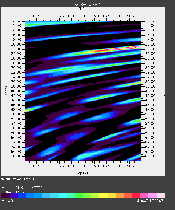
| Estimated Moho Depth: |
21.0 km |
| Estimated Crust Vp/Vs: |
2.07 |
| Assumed Crust Vp: |
6.566 km/s |
| Estimated Crust Vs: |
3.168 km/s |
| Estimated Crust Poisson's Ratio: |
0.35 |
|
| Radial Match: |
90.5618 % |
| Radial Bump: |
400 |
| Transverse Match: |
90.826004 % |
| Transverse Bump: |
400 |
| SOD ConfigId: |
31937991 |
| Insert Time: |
2023-08-25 00:24:41.311 +0000 |
| GWidth: |
2.5 |
| Max Bumps: |
400 |
| Tol: |
0.001 |
|

Signal To Noise
| Channel | StoN | STA | LTA |
| AV:SPCN: :BHZ:20230811T00:22:01.199Z | 3.0993268 | 8.324004E-7 | 2.6857458E-7 |
| AV:SPCN: :BHN:20230811T00:22:01.199Z | 1.2028012 | 7.7303514E-7 | 6.426957E-7 |
| AV:SPCN: :BHE:20230811T00:22:01.199Z | 1.0154264 | 8.0083026E-7 | 7.8866407E-7 |
| Arrivals |
| Ps | 3.6 SECOND |
| PpPs | 9.3 SECOND |
| PsPs/PpSs | 13 SECOND |


