You are here: Home > Network List > TA - USArray Transportable Network (new EarthScope stations) Stations List
> Station C22A Vida, MT, USA > Earthquake Result Viewer
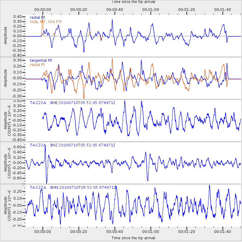
C22A Vida, MT, USA - Earthquake Result Viewer
*The percent match for this event was below the threshold and hence no stack was calculated.
| Earthquake location: |
Mariana Islands |
| Earthquake latitude/longitude: |
14.0/145.0 |
| Earthquake time(UTC): |
2010/07/10 (191) 05:39:43 GMT |
| Earthquake Depth: |
136 km |
| Earthquake Magnitude: |
5.6 MB, 5.6 MW, 5.5 MW |
| Earthquake Catalog/Contributor: |
WHDF/NEIC |
|
| Network: |
TA USArray Transportable Network (new EarthScope stations) |
| Station: |
C22A Vida, MT, USA |
| Lat/Lon: |
47.75 N/105.88 W |
| Elevation: |
745 m |
|
| Distance: |
92.1 deg |
| Az: |
39.659 deg |
| Baz: |
293.38 deg |
| Ray Param: |
$rayparam |
*The percent match for this event was below the threshold and hence was not used in the summary stack. |
|
| Radial Match: |
52.348568 % |
| Radial Bump: |
400 |
| Transverse Match: |
55.25631 % |
| Transverse Bump: |
400 |
| SOD ConfigId: |
319893 |
| Insert Time: |
2011-01-05 01:12:16.478 +0000 |
| GWidth: |
2.5 |
| Max Bumps: |
400 |
| Tol: |
0.001 |
|
Signal To Noise
| Channel | StoN | STA | LTA |
| TA:C22A: :BHZ:20100710T05:52:05.674971Z | 3.7934706 | 3.181009E-7 | 8.385484E-8 |
| TA:C22A: :BHN:20100710T05:52:05.674971Z | 1.7170398 | 1.3088643E-7 | 7.622796E-8 |
| TA:C22A: :BHE:20100710T05:52:05.674971Z | 1.0888361 | 1.4289645E-7 | 1.312378E-7 |
| Arrivals |
| Ps | |
| PpPs | |
| PsPs/PpSs | |


