You are here: Home > Network List > TA - USArray Transportable Network (new EarthScope stations) Stations List
> Station C23A Lambert, MT, USA > Earthquake Result Viewer
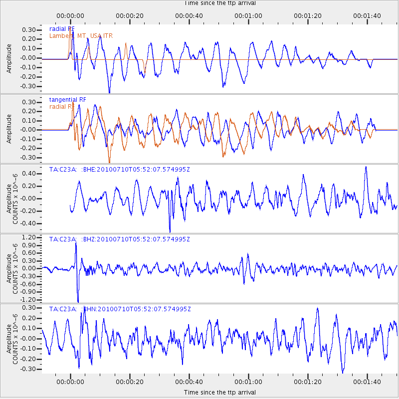
C23A Lambert, MT, USA - Earthquake Result Viewer
*The percent match for this event was below the threshold and hence no stack was calculated.
| Earthquake location: |
Mariana Islands |
| Earthquake latitude/longitude: |
14.0/145.0 |
| Earthquake time(UTC): |
2010/07/10 (191) 05:39:43 GMT |
| Earthquake Depth: |
136 km |
| Earthquake Magnitude: |
5.6 MB, 5.6 MW, 5.5 MW |
| Earthquake Catalog/Contributor: |
WHDF/NEIC |
|
| Network: |
TA USArray Transportable Network (new EarthScope stations) |
| Station: |
C23A Lambert, MT, USA |
| Lat/Lon: |
47.80 N/105.18 W |
| Elevation: |
729 m |
|
| Distance: |
92.5 deg |
| Az: |
39.417 deg |
| Baz: |
293.907 deg |
| Ray Param: |
$rayparam |
*The percent match for this event was below the threshold and hence was not used in the summary stack. |
|
| Radial Match: |
60.145557 % |
| Radial Bump: |
400 |
| Transverse Match: |
67.24032 % |
| Transverse Bump: |
400 |
| SOD ConfigId: |
319893 |
| Insert Time: |
2011-01-05 01:12:16.901 +0000 |
| GWidth: |
2.5 |
| Max Bumps: |
400 |
| Tol: |
0.001 |
|
Signal To Noise
| Channel | StoN | STA | LTA |
| TA:C23A: :BHZ:20100710T05:52:07.574995Z | 7.0582957 | 4.5551448E-7 | 6.4536046E-8 |
| TA:C23A: :BHN:20100710T05:52:07.574995Z | 1.7977334 | 1.6413496E-7 | 9.1301054E-8 |
| TA:C23A: :BHE:20100710T05:52:07.574995Z | 1.2513973 | 1.7659023E-7 | 1.4111444E-7 |
| Arrivals |
| Ps | |
| PpPs | |
| PsPs/PpSs | |


