You are here: Home > Network List > GS - US Geological Survey Networks Stations List
> Station OK051 E0350 and S34600 roads, Ralston OK > Earthquake Result Viewer
OK051 E0350 and S34600 roads, Ralston OK - Earthquake Result Viewer
| Earthquake location: |
Hokkaido, Japan Region |
| Earthquake latitude/longitude: |
41.1/142.8 |
| Earthquake time(UTC): |
2023/08/11 (223) 00:14:32 GMT |
| Earthquake Depth: |
30 km |
| Earthquake Magnitude: |
5.9 mww |
| Earthquake Catalog/Contributor: |
NEIC PDE/us |
|
| Network: |
GS US Geological Survey Networks |
| Station: |
OK051 E0350 and S34600 roads, Ralston OK |
| Lat/Lon: |
36.50 N/96.84 W |
| Elevation: |
263 m |
|
| Distance: |
85.4 deg |
| Az: |
44.25 deg |
| Baz: |
319.134 deg |
| Ray Param: |
0.04477911 |
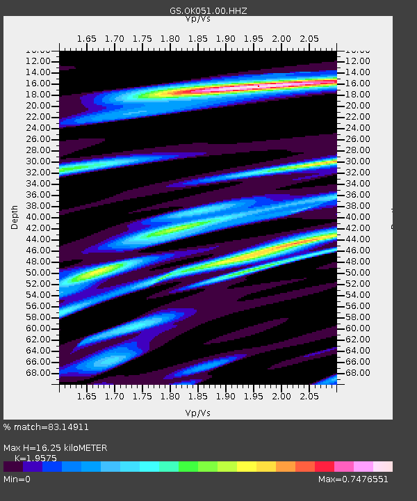
| Estimated Moho Depth: |
16.25 km |
| Estimated Crust Vp/Vs: |
1.96 |
| Assumed Crust Vp: |
6.483 km/s |
| Estimated Crust Vs: |
3.312 km/s |
| Estimated Crust Poisson's Ratio: |
0.32 |
|
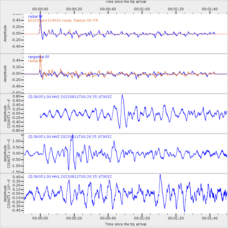
| Radial Match: |
83.14911 % |
| Radial Bump: |
400 |
| Transverse Match: |
65.99157 % |
| Transverse Bump: |
400 |
| SOD ConfigId: |
31937991 |
| Insert Time: |
2023-08-25 00:34:20.088 +0000 |
| GWidth: |
2.5 |
| Max Bumps: |
400 |
| Tol: |
0.001 |
|
Signal To Noise
| Channel | StoN | STA | LTA |
| GS:OK051:00:HHZ:20230811T00:26:35.97903Z | 2.7662938 | 3.9171277E-7 | 1.4160202E-7 |
| GS:OK051:00:HH1:20230811T00:26:35.97903Z | 1.0133946 | 9.32082E-8 | 9.197622E-8 |
| GS:OK051:00:HH2:20230811T00:26:35.97903Z | 1.461531 | 1.6955718E-7 | 1.16013396E-7 |
| Arrivals |
| Ps | 2.5 SECOND |
| PpPs | 7.3 SECOND |
| PsPs/PpSs | 9.7 SECOND |


