You are here: Home > Network List > TA - USArray Transportable Network (new EarthScope stations) Stations List
> Station K29A Lazy Trails Angus Ranch, Wood Lake, NE, USA > Earthquake Result Viewer
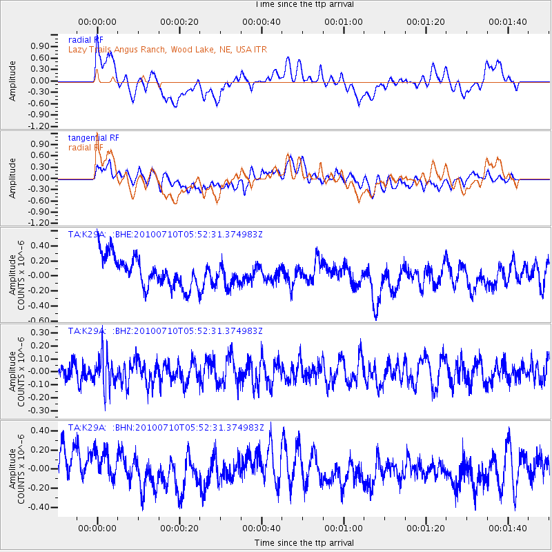
K29A Lazy Trails Angus Ranch, Wood Lake, NE, USA - Earthquake Result Viewer
*The percent match for this event was below the threshold and hence no stack was calculated.
| Earthquake location: |
Mariana Islands |
| Earthquake latitude/longitude: |
14.0/145.0 |
| Earthquake time(UTC): |
2010/07/10 (191) 05:39:43 GMT |
| Earthquake Depth: |
136 km |
| Earthquake Magnitude: |
5.6 MB, 5.6 MW, 5.5 MW |
| Earthquake Catalog/Contributor: |
WHDF/NEIC |
|
| Network: |
TA USArray Transportable Network (new EarthScope stations) |
| Station: |
K29A Lazy Trails Angus Ranch, Wood Lake, NE, USA |
| Lat/Lon: |
42.76 N/100.32 W |
| Elevation: |
840 m |
|
| Distance: |
97.8 deg |
| Az: |
42.497 deg |
| Baz: |
297.08 deg |
| Ray Param: |
$rayparam |
*The percent match for this event was below the threshold and hence was not used in the summary stack. |
|
| Radial Match: |
42.38146 % |
| Radial Bump: |
400 |
| Transverse Match: |
40.206448 % |
| Transverse Bump: |
400 |
| SOD ConfigId: |
319893 |
| Insert Time: |
2011-01-05 01:15:25.316 +0000 |
| GWidth: |
2.5 |
| Max Bumps: |
400 |
| Tol: |
0.001 |
|
Signal To Noise
| Channel | StoN | STA | LTA |
| TA:K29A: :BHZ:20100710T05:52:31.374983Z | 1.6582977 | 1.2337986E-7 | 7.440152E-8 |
| TA:K29A: :BHN:20100710T05:52:31.374983Z | 0.99871624 | 1.849678E-7 | 1.8520556E-7 |
| TA:K29A: :BHE:20100710T05:52:31.374983Z | 0.7405316 | 1.5108836E-7 | 2.0402689E-7 |
| Arrivals |
| Ps | |
| PpPs | |
| PsPs/PpSs | |


