You are here: Home > Network List > TA - USArray Transportable Network (new EarthScope stations) Stations List
> Station G26A Maurine, SD, USA > Earthquake Result Viewer
G26A Maurine, SD, USA - Earthquake Result Viewer
*The percent match for this event was below the threshold and hence no stack was calculated.
| Earthquake location: |
Mariana Islands |
| Earthquake latitude/longitude: |
14.0/145.0 |
| Earthquake time(UTC): |
2010/07/10 (191) 05:39:43 GMT |
| Earthquake Depth: |
136 km |
| Earthquake Magnitude: |
5.6 MB, 5.6 MW, 5.5 MW |
| Earthquake Catalog/Contributor: |
WHDF/NEIC |
|
| Network: |
TA USArray Transportable Network (new EarthScope stations) |
| Station: |
G26A Maurine, SD, USA |
| Lat/Lon: |
45.29 N/102.60 W |
| Elevation: |
833 m |
|
| Distance: |
95.2 deg |
| Az: |
40.95 deg |
| Baz: |
295.675 deg |
| Ray Param: |
$rayparam |
*The percent match for this event was below the threshold and hence was not used in the summary stack. |
|
| Radial Match: |
57.447052 % |
| Radial Bump: |
389 |
| Transverse Match: |
42.731228 % |
| Transverse Bump: |
345 |
| SOD ConfigId: |
319893 |
| Insert Time: |
2011-01-05 01:16:26.472 +0000 |
| GWidth: |
2.5 |
| Max Bumps: |
400 |
| Tol: |
0.001 |
|
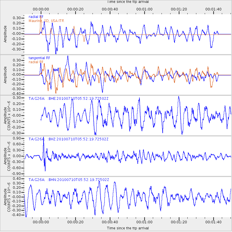
Signal To Noise
| Channel | StoN | STA | LTA |
| TA:G26A: :BHZ:20100710T05:52:19.72502Z | 4.1548867 | 3.153004E-7 | 7.5886646E-8 |
| TA:G26A: :BHN:20100710T05:52:19.72502Z | 0.70839685 | 1.1044806E-7 | 1.5591269E-7 |
| TA:G26A: :BHE:20100710T05:52:19.72502Z | 1.8209786 | 2.105871E-7 | 1.15645015E-7 |
| Arrivals |
| Ps | |
| PpPs | |
| PsPs/PpSs | |


