You are here: Home > Network List > TA - USArray Transportable Network (new EarthScope stations) Stations List
> Station A26A Wade Farm, Kenmare, ND, USA > Earthquake Result Viewer
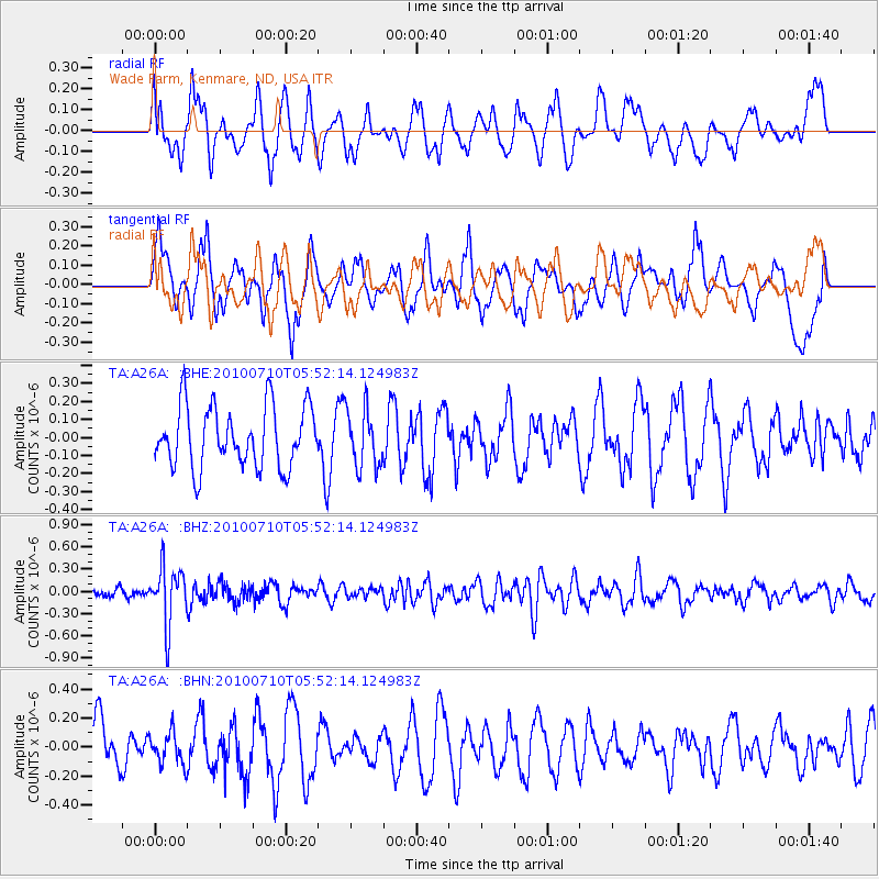
A26A Wade Farm, Kenmare, ND, USA - Earthquake Result Viewer
*The percent match for this event was below the threshold and hence no stack was calculated.
| Earthquake location: |
Mariana Islands |
| Earthquake latitude/longitude: |
14.0/145.0 |
| Earthquake time(UTC): |
2010/07/10 (191) 05:39:43 GMT |
| Earthquake Depth: |
136 km |
| Earthquake Magnitude: |
5.6 MB, 5.6 MW, 5.5 MW |
| Earthquake Catalog/Contributor: |
WHDF/NEIC |
|
| Network: |
TA USArray Transportable Network (new EarthScope stations) |
| Station: |
A26A Wade Farm, Kenmare, ND, USA |
| Lat/Lon: |
48.90 N/102.04 W |
| Elevation: |
570 m |
|
| Distance: |
94.0 deg |
| Az: |
37.531 deg |
| Baz: |
296.357 deg |
| Ray Param: |
$rayparam |
*The percent match for this event was below the threshold and hence was not used in the summary stack. |
|
| Radial Match: |
50.89082 % |
| Radial Bump: |
400 |
| Transverse Match: |
54.52526 % |
| Transverse Bump: |
400 |
| SOD ConfigId: |
319893 |
| Insert Time: |
2011-01-05 01:17:14.684 +0000 |
| GWidth: |
2.5 |
| Max Bumps: |
400 |
| Tol: |
0.001 |
|
Signal To Noise
| Channel | StoN | STA | LTA |
| TA:A26A: :BHZ:20100710T05:52:14.124983Z | 5.181285 | 3.8575698E-7 | 7.445199E-8 |
| TA:A26A: :BHN:20100710T05:52:14.124983Z | 0.744975 | 1.07648404E-7 | 1.4449935E-7 |
| TA:A26A: :BHE:20100710T05:52:14.124983Z | 0.9493444 | 1.6058314E-7 | 1.6915163E-7 |
| Arrivals |
| Ps | |
| PpPs | |
| PsPs/PpSs | |


