You are here: Home > Network List > G - GEOSCOPE Stations List
> Station SANVU Espiritu Santo, Vanuatu > Earthquake Result Viewer
SANVU Espiritu Santo, Vanuatu - Earthquake Result Viewer
| Earthquake location: |
Komandorskiye Ostrova Region |
| Earthquake latitude/longitude: |
54.8/164.8 |
| Earthquake time(UTC): |
2018/12/20 (354) 17:01:56 GMT |
| Earthquake Depth: |
33 km |
| Earthquake Magnitude: |
7.3 Mi |
| Earthquake Catalog/Contributor: |
NEIC PDE/pt |
|
| Network: |
G GEOSCOPE |
| Station: |
SANVU Espiritu Santo, Vanuatu |
| Lat/Lon: |
15.45 S/167.20 E |
| Elevation: |
56 m |
|
| Distance: |
70.0 deg |
| Az: |
177.562 deg |
| Baz: |
358.538 deg |
| Ray Param: |
0.055192955 |
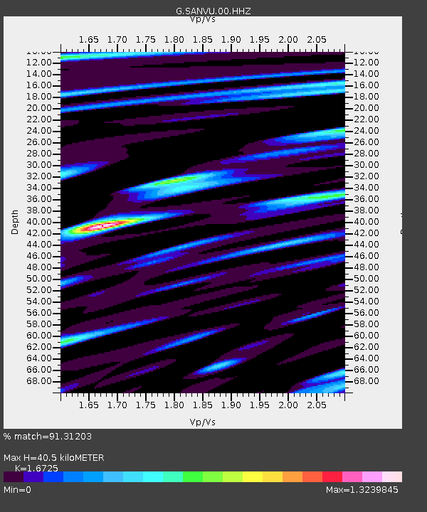
| Estimated Moho Depth: |
40.5 km |
| Estimated Crust Vp/Vs: |
1.67 |
| Assumed Crust Vp: |
4.802 km/s |
| Estimated Crust Vs: |
2.871 km/s |
| Estimated Crust Poisson's Ratio: |
0.22 |
|
| Radial Match: |
91.31203 % |
| Radial Bump: |
400 |
| Transverse Match: |
87.4134 % |
| Transverse Bump: |
400 |
| SOD ConfigId: |
3201911 |
| Insert Time: |
2019-01-03 17:13:15.263 +0000 |
| GWidth: |
2.5 |
| Max Bumps: |
400 |
| Tol: |
0.001 |
|

Signal To Noise
| Channel | StoN | STA | LTA |
| G:SANVU:00:HHZ:20181220T17:12:33.658997Z | 5.7758007 | 1.878253E-6 | 3.2519353E-7 |
| G:SANVU:00:HHN:20181220T17:12:33.658997Z | 1.5054338 | 4.6890128E-7 | 3.1147255E-7 |
| G:SANVU:00:HHE:20181220T17:12:33.658997Z | 1.3102347 | 5.5943195E-7 | 4.269708E-7 |
| Arrivals |
| Ps | 5.8 SECOND |
| PpPs | 22 SECOND |
| PsPs/PpSs | 28 SECOND |


