You are here: Home > Network List > N4 - Central and EAstern US Network Stations List
> Station SUSD Miller, SD, USA > Earthquake Result Viewer
SUSD Miller, SD, USA - Earthquake Result Viewer
| Earthquake location: |
Hokkaido, Japan Region |
| Earthquake latitude/longitude: |
41.1/142.8 |
| Earthquake time(UTC): |
2023/08/11 (223) 00:14:32 GMT |
| Earthquake Depth: |
30 km |
| Earthquake Magnitude: |
5.9 mww |
| Earthquake Catalog/Contributor: |
NEIC PDE/us |
|
| Network: |
N4 Central and EAstern US Network |
| Station: |
SUSD Miller, SD, USA |
| Lat/Lon: |
44.44 N/98.96 W |
| Elevation: |
520 m |
|
| Distance: |
78.4 deg |
| Az: |
40.127 deg |
| Baz: |
317.175 deg |
| Ray Param: |
0.049646985 |
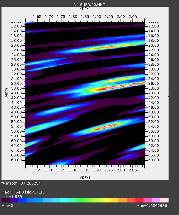
| Estimated Moho Depth: |
54.0 km |
| Estimated Crust Vp/Vs: |
1.93 |
| Assumed Crust Vp: |
6.53 km/s |
| Estimated Crust Vs: |
3.375 km/s |
| Estimated Crust Poisson's Ratio: |
0.32 |
|
| Radial Match: |
87.260254 % |
| Radial Bump: |
400 |
| Transverse Match: |
80.3426 % |
| Transverse Bump: |
400 |
| SOD ConfigId: |
31937991 |
| Insert Time: |
2023-08-25 00:40:12.534 +0000 |
| GWidth: |
2.5 |
| Max Bumps: |
400 |
| Tol: |
0.001 |
|

Signal To Noise
| Channel | StoN | STA | LTA |
| N4:SUSD:00:HHZ:20230811T00:25:59.368983Z | 4.0867496 | 6.045993E-7 | 1.4794136E-7 |
| N4:SUSD:00:HH1:20230811T00:25:59.368983Z | 1.4840387 | 4.0140364E-7 | 2.704806E-7 |
| N4:SUSD:00:HH2:20230811T00:25:59.368983Z | 1.8753803 | 4.3069022E-7 | 2.2965487E-7 |
| Arrivals |
| Ps | 8.0 SECOND |
| PpPs | 24 SECOND |
| PsPs/PpSs | 32 SECOND |


