You are here: Home > Network List > NE - New England Seismic Network Stations List
> Station EMMW Machias, ME, USA > Earthquake Result Viewer
EMMW Machias, ME, USA - Earthquake Result Viewer
*The percent match for this event was below the threshold and hence no stack was calculated.
| Earthquake location: |
Hokkaido, Japan Region |
| Earthquake latitude/longitude: |
41.1/142.8 |
| Earthquake time(UTC): |
2023/08/11 (223) 00:14:32 GMT |
| Earthquake Depth: |
30 km |
| Earthquake Magnitude: |
5.9 mww |
| Earthquake Catalog/Contributor: |
NEIC PDE/us |
|
| Network: |
NE New England Seismic Network |
| Station: |
EMMW Machias, ME, USA |
| Lat/Lon: |
44.71 N/67.46 W |
| Elevation: |
35 m |
|
| Distance: |
90.3 deg |
| Az: |
21.087 deg |
| Baz: |
337.592 deg |
| Ray Param: |
$rayparam |
*The percent match for this event was below the threshold and hence was not used in the summary stack. |
|
| Radial Match: |
53.45418 % |
| Radial Bump: |
400 |
| Transverse Match: |
80.428345 % |
| Transverse Bump: |
400 |
| SOD ConfigId: |
31937991 |
| Insert Time: |
2023-08-25 00:41:00.131 +0000 |
| GWidth: |
2.5 |
| Max Bumps: |
400 |
| Tol: |
0.001 |
|
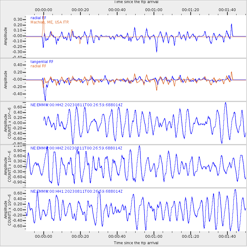
Signal To Noise
| Channel | StoN | STA | LTA |
| NE:EMMW:00:HHZ:20230811T00:26:59.688014Z | 1.8532553 | 6.976148E-7 | 3.764267E-7 |
| NE:EMMW:00:HH1:20230811T00:26:59.688014Z | 0.5837207 | 1.9755505E-7 | 3.3844108E-7 |
| NE:EMMW:00:HH2:20230811T00:26:59.688014Z | 0.8938772 | 2.775289E-7 | 3.1047765E-7 |
| Arrivals |
| Ps | |
| PpPs | |
| PsPs/PpSs | |


