You are here: Home > Network List > II - Global Seismograph Network (GSN - IRIS/IDA) Stations List
> Station LVZ Lovozero, Russia > Earthquake Result Viewer
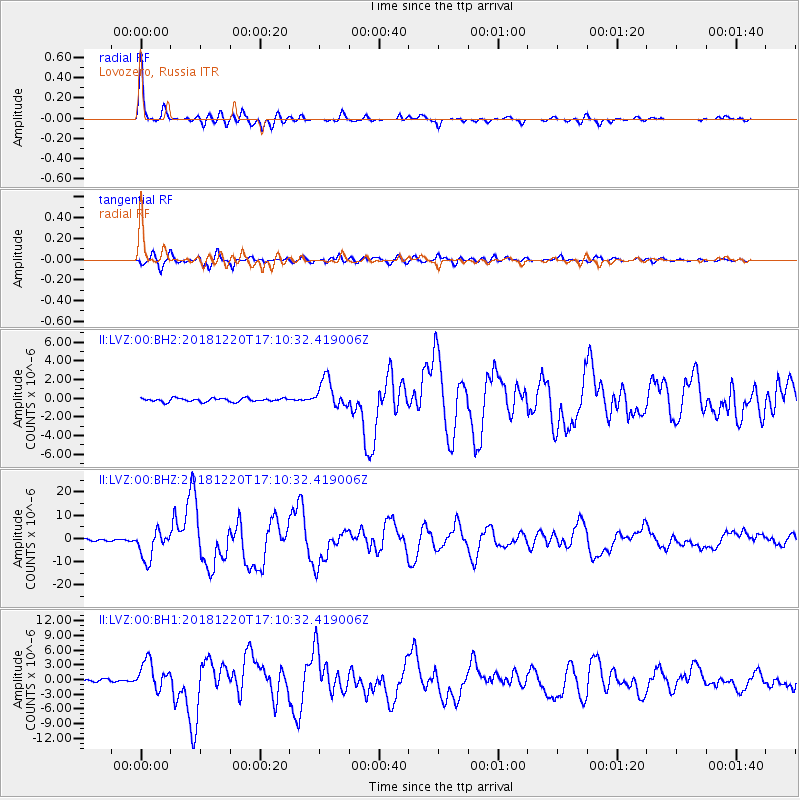
LVZ Lovozero, Russia - Earthquake Result Viewer

| Earthquake location: |
Komandorskiye Ostrova Region |
| Earthquake latitude/longitude: |
54.8/164.8 |
| Earthquake time(UTC): |
2018/12/20 (354) 17:01:56 GMT |
| Earthquake Depth: |
33 km |
| Earthquake Magnitude: |
7.3 Mi |
| Earthquake Catalog/Contributor: |
NEIC PDE/pt |
|
| Network: |
II Global Seismograph Network (GSN - IRIS/IDA) |
| Station: |
LVZ Lovozero, Russia |
| Lat/Lon: |
67.90 N/34.65 E |
| Elevation: |
630 m |
|
| Distance: |
52.1 deg |
| Az: |
338.512 deg |
| Baz: |
34.042 deg |
| Ray Param: |
0.066899255 |
| Estimated Moho Depth: |
39.75 km |
| Estimated Crust Vp/Vs: |
1.60 |
| Assumed Crust Vp: |
6.367 km/s |
| Estimated Crust Vs: |
3.979 km/s |
| Estimated Crust Poisson's Ratio: |
0.18 |
|
| Radial Match: |
96.50731 % |
| Radial Bump: |
327 |
| Transverse Match: |
91.73489 % |
| Transverse Bump: |
400 |
| SOD ConfigId: |
3201911 |
| Insert Time: |
2019-01-03 17:14:08.149 +0000 |
| GWidth: |
2.5 |
| Max Bumps: |
400 |
| Tol: |
0.001 |
|
Signal To Noise
| Channel | StoN | STA | LTA |
| II:LVZ:00:BHZ:20181220T17:10:32.419006Z | 13.777449 | 6.1285778E-6 | 4.4482675E-7 |
| II:LVZ:00:BH1:20181220T17:10:32.419006Z | 11.045125 | 2.872503E-6 | 2.6006975E-7 |
| II:LVZ:00:BH2:20181220T17:10:32.419006Z | 8.199837 | 1.5209354E-6 | 1.8548361E-7 |
| Arrivals |
| Ps | 4.0 SECOND |
| PpPs | 15 SECOND |
| PsPs/PpSs | 19 SECOND |


