You are here: Home > Network List > IU - Global Seismograph Network (GSN - IRIS/USGS) Stations List
> Station COR Corvallis, Oregon, USA > Earthquake Result Viewer
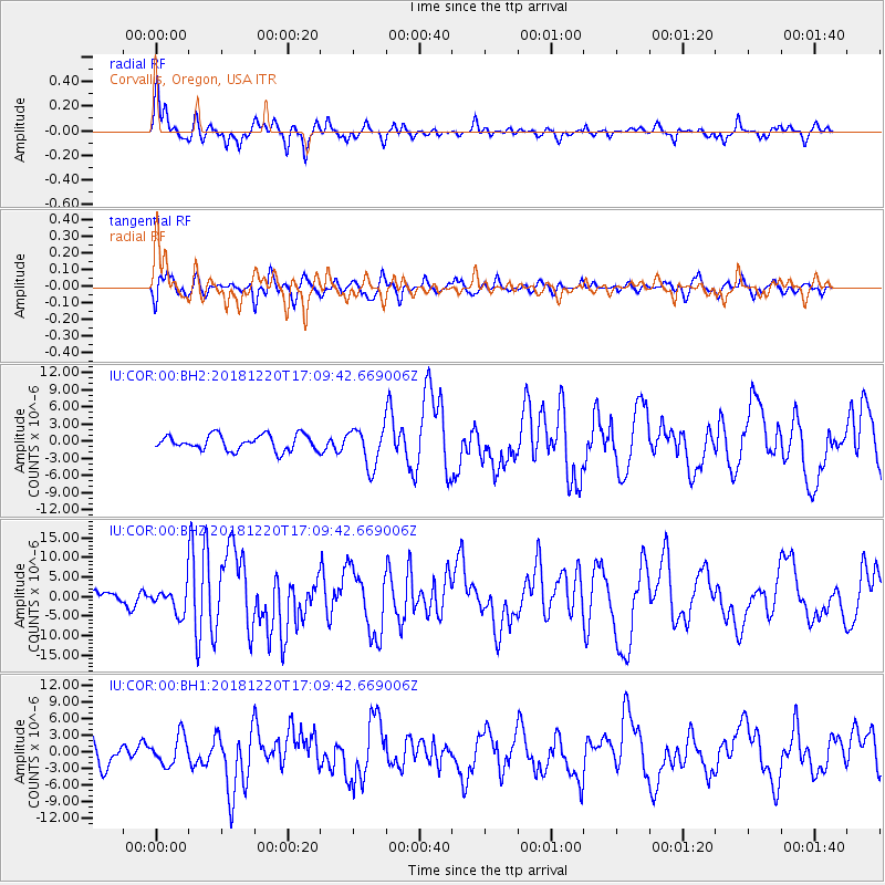
COR Corvallis, Oregon, USA - Earthquake Result Viewer
*The percent match for this event was below the threshold and hence no stack was calculated.
| Earthquake location: |
Komandorskiye Ostrova Region |
| Earthquake latitude/longitude: |
54.8/164.8 |
| Earthquake time(UTC): |
2018/12/20 (354) 17:01:56 GMT |
| Earthquake Depth: |
33 km |
| Earthquake Magnitude: |
7.3 Mi |
| Earthquake Catalog/Contributor: |
NEIC PDE/pt |
|
| Network: |
IU Global Seismograph Network (GSN - IRIS/USGS) |
| Station: |
COR Corvallis, Oregon, USA |
| Lat/Lon: |
44.59 N/123.30 W |
| Elevation: |
110 m |
|
| Distance: |
45.6 deg |
| Az: |
71.808 deg |
| Baz: |
309.746 deg |
| Ray Param: |
$rayparam |
*The percent match for this event was below the threshold and hence was not used in the summary stack. |
|
| Radial Match: |
71.822716 % |
| Radial Bump: |
391 |
| Transverse Match: |
62.423733 % |
| Transverse Bump: |
400 |
| SOD ConfigId: |
3201911 |
| Insert Time: |
2019-01-03 17:14:18.854 +0000 |
| GWidth: |
2.5 |
| Max Bumps: |
400 |
| Tol: |
0.001 |
|
Signal To Noise
| Channel | StoN | STA | LTA |
| IU:COR:00:BHZ:20181220T17:09:42.669006Z | 1.5469353 | 3.210563E-6 | 2.0754346E-6 |
| IU:COR:00:BH1:20181220T17:09:42.669006Z | 0.94602585 | 2.635465E-6 | 2.7858277E-6 |
| IU:COR:00:BH2:20181220T17:09:42.669006Z | 2.5267673 | 3.386885E-6 | 1.3404024E-6 |
| Arrivals |
| Ps | |
| PpPs | |
| PsPs/PpSs | |


