You are here: Home > Network List > IU - Global Seismograph Network (GSN - IRIS/USGS) Stations List
> Station FUNA Funafuti, Tuvalu > Earthquake Result Viewer
FUNA Funafuti, Tuvalu - Earthquake Result Viewer

| Earthquake location: |
Komandorskiye Ostrova Region |
| Earthquake latitude/longitude: |
54.8/164.8 |
| Earthquake time(UTC): |
2018/12/20 (354) 17:01:56 GMT |
| Earthquake Depth: |
33 km |
| Earthquake Magnitude: |
7.3 Mi |
| Earthquake Catalog/Contributor: |
NEIC PDE/pt |
|
| Network: |
IU Global Seismograph Network (GSN - IRIS/USGS) |
| Station: |
FUNA Funafuti, Tuvalu |
| Lat/Lon: |
8.53 S/179.20 E |
| Elevation: |
20 m |
|
| Distance: |
64.3 deg |
| Az: |
164.189 deg |
| Baz: |
350.833 deg |
| Ray Param: |
0.05897006 |
| Estimated Moho Depth: |
57.5 km |
| Estimated Crust Vp/Vs: |
1.92 |
| Assumed Crust Vp: |
4.24 km/s |
| Estimated Crust Vs: |
2.208 km/s |
| Estimated Crust Poisson's Ratio: |
0.31 |
|
| Radial Match: |
85.14292 % |
| Radial Bump: |
325 |
| Transverse Match: |
79.38859 % |
| Transverse Bump: |
400 |
| SOD ConfigId: |
3201911 |
| Insert Time: |
2019-01-03 17:14:23.148 +0000 |
| GWidth: |
2.5 |
| Max Bumps: |
400 |
| Tol: |
0.001 |
|
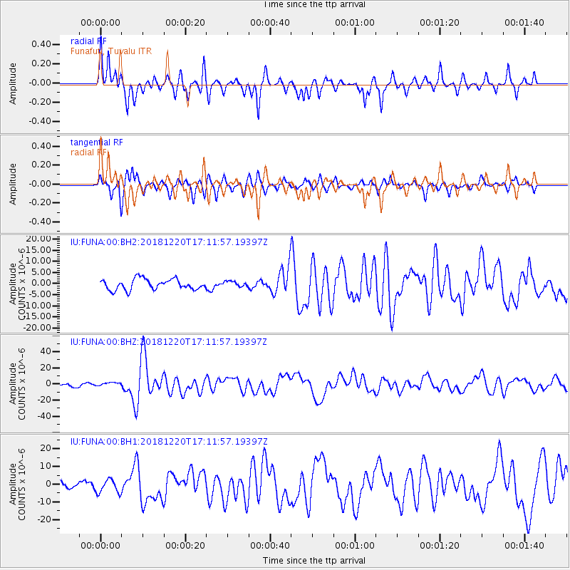
Signal To Noise
| Channel | StoN | STA | LTA |
| IU:FUNA:00:BHZ:20181220T17:11:57.19397Z | 0.7797768 | 2.2357729E-6 | 2.8671957E-6 |
| IU:FUNA:00:BH1:20181220T17:11:57.19397Z | 2.1744926 | 3.8838343E-6 | 1.7860876E-6 |
| IU:FUNA:00:BH2:20181220T17:11:57.19397Z | 0.50699574 | 1.2100385E-6 | 2.3866835E-6 |
| Arrivals |
| Ps | 13 SECOND |
| PpPs | 39 SECOND |
| PsPs/PpSs | 52 SECOND |


