You are here: Home > Network List > US - United States National Seismic Network Stations List
> Station DGMT Dagmar, Montana, USA > Earthquake Result Viewer
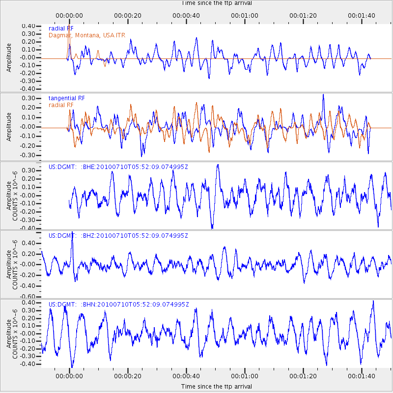
DGMT Dagmar, Montana, USA - Earthquake Result Viewer
*The percent match for this event was below the threshold and hence no stack was calculated.
| Earthquake location: |
Mariana Islands |
| Earthquake latitude/longitude: |
14.0/145.0 |
| Earthquake time(UTC): |
2010/07/10 (191) 05:39:43 GMT |
| Earthquake Depth: |
136 km |
| Earthquake Magnitude: |
5.6 MB, 5.6 MW, 5.5 MW |
| Earthquake Catalog/Contributor: |
WHDF/NEIC |
|
| Network: |
US United States National Seismic Network |
| Station: |
DGMT Dagmar, Montana, USA |
| Lat/Lon: |
48.47 N/104.20 W |
| Elevation: |
0.0 m |
|
| Distance: |
92.8 deg |
| Az: |
38.534 deg |
| Baz: |
294.682 deg |
| Ray Param: |
$rayparam |
*The percent match for this event was below the threshold and hence was not used in the summary stack. |
|
| Radial Match: |
53.543694 % |
| Radial Bump: |
400 |
| Transverse Match: |
44.77311 % |
| Transverse Bump: |
400 |
| SOD ConfigId: |
319893 |
| Insert Time: |
2011-01-05 01:21:46.189 +0000 |
| GWidth: |
2.5 |
| Max Bumps: |
400 |
| Tol: |
0.001 |
|
Signal To Noise
| Channel | StoN | STA | LTA |
| US:DGMT: :BHZ:20100710T05:52:09.074995Z | 1.6189408 | 1.9606249E-7 | 1.211054E-7 |
| US:DGMT: :BHN:20100710T05:52:09.074995Z | 2.4428887 | 2.478694E-7 | 1.0146569E-7 |
| US:DGMT: :BHE:20100710T05:52:09.074995Z | 1.1025422 | 1.2680468E-7 | 1.15011176E-7 |
| Arrivals |
| Ps | |
| PpPs | |
| PsPs/PpSs | |


